
Originally posted by Phil Carter
View Post
Whitechapel Registration District / Poor Law Union:
- The Liberty of Norton Folgate
- The Old Artillery Ground
- The Parish of Christ Church Spitalfields
- The Hamlet of Mile End New Town
- The Parish of Holy Trinity ('Minories')
- The Parish of St. Mary Whitechapel (portion within the County of Middlesex, -1889; the County of London, 1889-1965)
- The Liberty of Her Majesty's Tower of London
--- {The Liberty of the Tower}
--- {The Precinct of Old Tower Without}
--- {The Tower}
- The Precinct of St. Katharine
- The Parish of St. Botolph without Aldgate (portion within the County of Middlesex, -1889; the County of London, 1889-1965)
- Total Population (1891 Census): 74,462
- Total Population (Charles Booth 1889 Estimate): 73,518
- Percentage of Total Population Living Below the 'Line of Poverty' (Charles Booth 1889 Estimate): 39.20%
- Percentage of Total Population Living Above the 'Line of Poverty' (Charles Booth 1889 Estimate): 60.80%
Mile End Old Town Registration District / Poor Law Parish:
- The Hamlet of Mile End Old Town
- Total Population (1891 Census): 107,592
- Total Population (Charles Booth 1889 Estimate): 110,321
- Percentage of Total Population Living Below the 'Line of Poverty' (Charles Booth 1889 Estimate): 26.20%
- Percentage of Total Population Living Above the 'Line of Poverty' (Charles Booth 1889 Estimate): 73.80%
St. George in the East Registration District / Poor Law Parish:
- The Parish of St. George in the East
- Total Population (1891 Census): 45,795
- Total Population (Charles Booth 1889 Estimate): 47,578
- Percentage of Total Population Living Below the 'Line of Poverty' (Charles Booth 1889 Estimate): 48.80%
- Percentage of Total Population Living Above the 'Line of Poverty' (Charles Booth 1889 Estimate): 51.20%
Stepney Registration District / Poor Law Union:
- The Parish of St. John of Wapping
- The Parish of St. Paul Shadwell
- The Hamlet of Ratcliff
- The Parish of St. Anne Limehouse
- Total Population (1891 Census): 57,376
- Total Population (Charles Booth 1889 Estimate): 62,063
- Percentage of Total Population Living Below the 'Line of Poverty' (Charles Booth 1889 Estimate): 38.10%
- Percentage of Total Population Living Above the 'Line of Poverty' (Charles Booth 1889 Estimate): 61.90%
Poplar Registration District / Poor Law Union:
- The Parish of St. Mary Stratford Bow
- The Parish of Bromley St. Leonard
- The Parish of All Saints Poplar
- Total Population (1891 Census): 166,748
- Total Population (Charles Booth 1889 Estimate): 166,393
- Percentage of Total Population Living Below the 'Line of Poverty' (Charles Booth 1889 Estimate): 36.50%
- Percentage of Total Population Living Above the 'Line of Poverty' (Charles Booth 1889 Estimate): 63.50%
Total (Tower Hamlets):
- Total Population (1891 Census): 451,973
- Total Population (Charles Booth 1889 Estimate): 459,873
- Percentage of Total Population Living Below the 'Line of Poverty' (Charles Booth 1889 Estimate): 35.95%
- Percentage of Total Population Living Above the 'Line of Poverty' (Charles Booth 1889 Estimate): 64.05%
The Parliamentary Borough of Shoreditch
Shoreditch Registration District / Poor Law Parish:
- The Parish of St. Leonard Shoreditch
- Total Population (1891 Census): 124,009
- Total Population (Charles Booth 1889 Estimate): 121,161
- Percentage of Total Population Living Below the 'Line of Poverty' (Charles Booth 1889 Estimate): 40.20%
- Percentage of Total Population Living Above the 'Line of Poverty' (Charles Booth 1889 Estimate): 59.80%
The Parliamentary Borough of Bethnal Green
Bethnal Green Registration District / Poor Law Parish:
- The Parish of St. Matthew Bethnal Green
- Total Population (1891 Census): 129,132
- Total Population (Charles Booth 1889 Estimate): 127,641
- Percentage of Total Population Living Below the 'Line of Poverty' (Charles Booth 1889 Estimate): 44.70%
- Percentage of Total Population Living Above the 'Line of Poverty' (Charles Booth 1889 Estimate): 55.30%
Total (London's 'East End'***):
- Total Population (1891 Census): 705,114
- Total Population (Charles Booth 1889 Estimate): 708,675
- Percentage of Total Population Living Below the 'Line of Poverty' (Charles Booth 1889 Estimate): 38.00%
- Percentage of Total Population Living Above the 'Line of Poverty' (Charles Booth 1889 Estimate): 62.00%
*** The most likely composition of London's 'East End', in the 1880's/1890's.
Other areas that could conceivably have been considered part of the 'East End', during that period:
- The Parish of St. Botolph without Bishopsgate (City of London)
- The Parish of St. Botolph without Aldgate (portion within the City of London)
- The Parish of St. Mary Whitechapel (portion within the City of London)
- The Parish of St. John at Hackney (County of Middlesex)
- The Parish of All Saints West Ham (County of Essex)
---------
Assuming a more detailed perspective of the 'Whitechapel' area; …
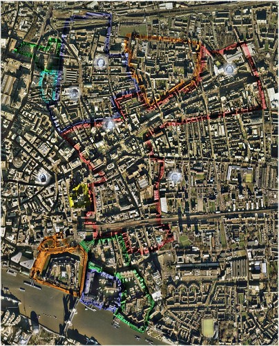
Whitechapel Registration District / Poor Law Union - 1888 (Click to Enlarge in flickr)
Underlying Aerial Imagery: Copyright Google Earth, 2007
Overlying Plots, Labels and Color-Shadings: Copyright Colin C. Roberts, 2009
Whitechapel Registration District / Poor Law Union:
- The Liberty of Norton Folgate (Green)
- The Old Artillery Ground (Aqua)
- The Parish of Christ Church Spitalfields (Blue)
- The Hamlet of Mile End New Town (Orange)
- The Parish of Holy Trinity ('Minories') (Yellow)
- The Parish of St. Mary Whitechapel (portion within the County of Middlesex, -1889; the County of London, 1889-1965) (Red)
- The Liberty of Her Majesty's Tower of London (Orange)
--- {The Liberty of the Tower}
--- {The Precinct of Old Tower Without}
--- {The Tower}
- The Precinct of St. Katharine (Blue)
- The Parish of St. Botolph without Aldgate (portion within the County of Middlesex, -1889; the County of London, 1889-1965) (Green)
- Total Population (1891 Census): 74,462
- Total Population (Charles Booth 1889 Estimate): 73,518
- Estimated Percentage; Class 'A' ('vicious' (i.e. vice-ridden), 'semi-criminal'): 3.30%
- Estimated Percentage; Class 'B' ('very poor'): 8.90%
- Estimated Percentage; Class 'C' ('poor' - irregular income): 10.70%
- Estimated Percentage; Class 'D' ('poor' - regular but inadequate income): 16.30%
- Estimated Percentage; Below the 'Line of Poverty': 39.20%
- Estimated Percentage; Class 'E' ('above the line of poverty' - regular 'standard' income): 43.30%
- Estimated Percentage; Class 'F' ('highly skilled labour'): 11.30%
- Estimated Percentage; Class 'G' ('lower middle-class'): 4.40%
- Estimated Percentage; Class 'H' ('upper middle-class'): 1.80%
- Estimated Percentage; Above the 'Line of Poverty': 60.80%


Leave a comment: