

 Tweet
Tweet
Fantastic work, Colin. Interesting to note he`d only been on the scene 5 months or so. Looking forward to more of this.
-
-


Comment
-
Originally posted by Septic Blue View PostHe claimed 'settlement' of five months, specifically within the boundaries of the Whitechapel Poor Law Union.Originally posted by Jon Guy View Post
He had to claim 'settlement' of some duration, in order to be admitted to the Whitechapel Union Infirmary. By claiming 'settlement' of at least one year, he would have ensured that the Guardians of the Whitechapel Poor Law Union could not have turned him over to the care of some other Poor Law entity (i.e. Parish or Union).
Again;
Of course, he could have been "on the scene" for quite some time, Jon; residing perhaps, just beyond the boundaries of the Whitechapel Poor Law Union.Originally posted by Septic Blue View Post
This John Simmonds, for instance �
� resided in the St. George in the East Poor Law Parish, in 1881. As such, he did not live within the boundaries of the Whitechapel Poor Law Union. But, as his domicile of 12 Denmark Street was situated more-or-less between Prince's Square and the Parish Church of St. George in the East, he would have been "on the scene", so to speak.Originally posted by Septic Blue View Post
Of course, at this point, we don't know that the two John Simmonds are one and the same. But, either way �
"Informal Preview of Geo-Spatial Analysis Project"Originally posted by Septic Blue View Post
"Informal Presentation of Geo-Spatial Analysis Project"
I am still in the process of compiling my "Informal Presentation". The following analysis will therefore require some clarification/explanation. So, ask questions, folks: � I will try to answer them.

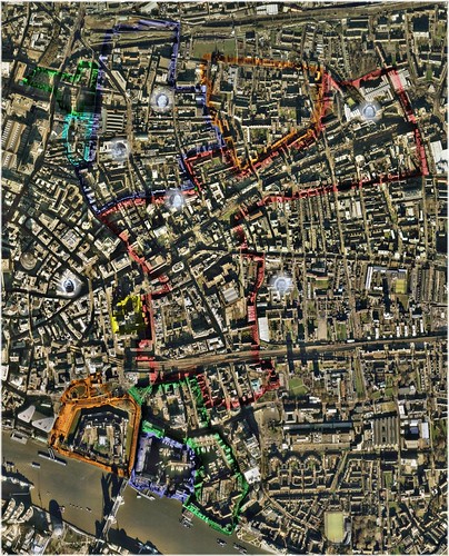
Deviations from Murder-Site Mean-Center (Elliptical Perspective) (Click to Enlarge in flickr)
Underlying Aerial Imagery: Copyright Google Earth, 2007
Overlying Plots, Labels and Color-Shadings: Copyright Colin C. Roberts, 2009
From the outside, in �
Mary Ann 'Polly' Nichols (Victim: 31 August 1888): Gateway to Brown's Stable Yard, Buck's Row, Parish of St. Mary Whitechapel, County of Middlesex
Longitude: 0� 3' 37.53" West
Latitude: 51� 31' 12.14" North
Standard Deviations from Murder-Site Mean-Center: 1.22
Semi-Major Axis (i.e. 'Long Radius'): 860.56 Yards
Semi-Minor Axis (i.e. 'Short Radius'): 610.38 Yards
Area: 0.53 Square Miles
Portion of Probability Distribution (Impending Subsequent Murders): 72.32%*
Portion of Probability Distribution (Geographic Profile Model): 38.18%**
* Given a perception of late November 1888 that this series of murders would continue ad infinitum; the expectation should have been that 72.32% would occur within the specified elliptical area, i.e. within 1.22 Standard Deviations of the murder-site Mean-Center (green dot).
This can be loosely interpreted to mean that in late November 1888, the perceived probability of the impending subsequent murder occurring within this elliptical area, should have been 72.32%.
** My Geographic Profile Model would suggest a 38.18% probability that the perpetrator(s) of these crimes operated from a base that was situated within the specified elliptical area, i.e. within 1.22 Standard Deviations of the murder-site Mean-Center (green dot).
Elizabeth Stride (Victim: 30 September 1888): Gateway to Dutfield's Yard, Berner Street, Parish of St. George in the East, County of Middlesex
Longitude: 0� 3' 56.14" West
Latitude: 51� 30' 49.44" North
Standard Deviations from Murder-Site Mean-Center: 1.13
Semi-Major Axis (i.e. 'Long Radius'): 802.49 Yards
Semi-Minor Axis (i.e. 'Short Radius'): 569.19 Yards
Area: 0.46 Square Miles
Portion of Probability Distribution (Impending Subsequent Murders): 69.02%*
Portion of Probability Distribution (Geographic Profile Model): 35.62%**
* Given a perception of late November 1888 that this series of murders would continue ad infinitum; the expectation should have been that 69.02% would occur within the specified elliptical area, i.e. within 1.13 Standard Deviations of the murder-site Mean-Center (green dot).
This can be loosely interpreted to mean that in late November 1888, the perceived probability of the impending subsequent murder occurring within this elliptical area, should have been 69.02%.
** My Geographic Profile Model would suggest a 35.62% probability that the perpetrator(s) of these crimes operated from a base that was situated within the specified elliptical area, i.e. within 1.13 Standard Deviations of the murder-site Mean-Center (green dot).
Catherine Eddowes (Victim: 30 September 1888): Southeast Corner of Mitre Square, Parish of St. James, Aldgate Ward, City of London
Longitude: 0� 4' 41.06" West
Latitude: 51� 30' 49.35" North
Standard Deviations from Murder-Site Mean-Center: 1.00
Semi-Major Axis (i.e. 'Long Radius'): 710.97 Yards
Semi-Minor Axis (i.e. 'Short Radius'): 504.27 Yards
Area: 0.36 Square Miles
Portion of Probability Distribution (Impending Subsequent Murders): 63.68%*
Portion of Probability Distribution (Geographic Profile Model): 31.84%**
* Given a perception of late November 1888 that this series of murders would continue ad infinitum; the expectation should have been that 63.68% would occur within the specified elliptical area, i.e. within 1.00 Standard Deviations of the murder-site Mean-Center (green dot).
This can be loosely interpreted to mean that in late November 1888, the perceived probability of the impending subsequent murder occurring within this elliptical area, should have been 63.68%.
** My Geographic Profile Model would suggest a 31.84% probability that the perpetrator(s) of these crimes operated from a base that was situated within the specified elliptical area, i.e. within 1.00 Standard Deviations of the murder-site Mean-Center (green dot).
Red Ellipse � One Standard Deviation
Standard Deviations from Murder-Site Mean-Center: 1.00
Semi-Major Axis (i.e. 'Long Radius'): 707.53 Yards
Semi-Minor Axis (i.e. 'Short Radius'): 501.83 Yards
Area: 0.36 Square Miles
Portion of Probability Distribution (Impending Subsequent Murders): 63.68%*
Portion of Probability Distribution (Geographic Profile Model): 31.84%**
* Given a perception of late November 1888 that this series of murders would continue ad infinitum; the expectation should have been that 63.68% would occur within the specified elliptical area, i.e. within 1.00 Standard Deviations of the murder-site Mean-Center (green dot).
This can be loosely interpreted to mean that in late November 1888, the perceived probability of the impending subsequent murder occurring within this elliptical area, should have been 63.68%.
** My Geographic Profile Model would suggest a 31.84% probability that the perpetrator(s) of these crimes operated from a base that was situated within the specified elliptical area, i.e. within 1.00 Standard Deviations of the murder-site Mean-Center (green dot).
Robert Mann (Modern-Day Person of Interest): Whitechapel Union Infirmary, Baker's Row, Hamlet of Mile End New Town, County of Middlesex
Longitude: 0� 3' 50.14" West
Latitude: 51� 31' 14.66" North
Standard Deviations from Murder-Site Mean-Center: 0.94
Semi-Major Axis (i.e. 'Long Radius'): 663.15 Yards
Semi-Minor Axis (i.e. 'Short Radius'): 470.36 Yards
Area: 0.32 Square Miles
Portion of Probability Distribution (Impending Subsequent Murders): 60.88%*
Portion of Probability Distribution (Geographic Profile Model): 30.00%**
* Given a perception of late November 1888 that this series of murders would continue ad infinitum; the expectation should have been that 60.88% would occur within the specified elliptical area, i.e. within 0.94 Standard Deviations of the murder-site Mean-Center (green dot).
This can be loosely interpreted to mean that in late November 1888, the perceived probability of the impending subsequent murder occurring within this elliptical area, should have been 60.88%.
** My Geographic Profile Model would suggest a 30.00% probability that the perpetrator(s) of these crimes operated from a base that was situated within the specified elliptical area, i.e. within 0.94 Standard Deviations of the murder-site Mean-Center (green dot).
*** This would suggest that the documented 1888 residence of Robert Mann (i.e. the Whitechapel Union Infirmary) should be perceived as having been in the 70th percentile (i.e. the top 30.00%) of all 'reasonable' possibilities for the location of the perpetrator's base of operations. ***
Annie Chapman (Victim: 8 September 1888): Back Yard of 29 Hanbury Street, Parish of Christ Church Spitalfields, County of Middlesex
Longitude: 0� 4' 21.40" West
Latitude: 51� 31' 13.67" North
Standard Deviations from Murder-Site Mean-Center: 0.82
Semi-Major Axis (i.e. 'Long Radius'): 583.65 Yards
Semi-Minor Axis (i.e. 'Short Radius'): 413.97 Yards
Area: 0.25 Square Miles
Portion of Probability Distribution (Impending Subsequent Murders): 55.04%*
Portion of Probability Distribution (Geographic Profile Model): 26.42%**
* Given a perception of late November 1888 that this series of murders would continue ad infinitum; the expectation should have been that 55.04% would occur within the specified elliptical area, i.e. within 0.82 Standard Deviations of the murder-site Mean-Center (green dot).
This can be loosely interpreted to mean that in late November 1888, the perceived probability of the impending subsequent murder occurring within this elliptical area, should have been 55.04%.
** My Geographic Profile Model would suggest a 26.42% probability that the perpetrator(s) of these crimes operated from a base that was situated within the specified elliptical area, i.e. within 0.82 Standard Deviations of the murder-site Mean-Center (green dot).
Robert Mann (Modern-Day Person of Interest): Whitechapel Union Infirmary Mortuary, Eagle Place, Old Montague Street, Hamlet of Mile End New Town, County of Middlesex
Longitude: 0� 3' 52.22" West
Latitude: 51� 31' 8.12" North
Standard Deviations from Murder-Site Mean-Center: 0.73
Semi-Major Axis (i.e. 'Long Radius'): 515.71 Yards
Semi-Minor Axis (i.e. 'Short Radius'): 365.78 Yards
Area: 0.19 Square Miles
Portion of Probability Distribution (Impending Subsequent Murders): 50.00%*
Portion of Probability Distribution (Geographic Profile Model): 23.54%**
* Given a perception of late November 1888 that this series of murders would continue ad infinitum; the expectation should have been that 50.00% would occur within the specified elliptical area, i.e. within 0.73 Standard Deviations of the murder-site Mean-Center (green dot).
This can be loosely interpreted to mean that in late November 1888, the perceived probability of the impending subsequent murder occurring within this elliptical area, should have been 50.00%.
** My Geographic Profile Model would suggest a 23.54% probability that the perpetrator(s) of these crimes operated from a base that was situated within the specified elliptical area, i.e. within 0.73 Standard Deviations of the murder-site Mean-Center (green dot).
*** This would suggest that the documented 1888 workplace of Robert Mann (i.e. the Whitechapel Union Infirmary Mortuary) should be perceived as having been in the 76th percentile (i.e. the top 23.54%) of all 'reasonable' possibilities for the location of the perpetrator's base of operations. ***
Mary Jane Kelly (Victim: 9 November 1888): Interior of 13 Miller's Court, Dorset Street, Parish of Christ Church Spitalfields, County of Middlesex
Longitude: 0� 4' 30.47" West
Latitude: 51� 31' 7.17" North
Standard Deviations from Murder-Site Mean-Center: 0.72
Semi-Major Axis (i.e. 'Long Radius'): 511.49 Yards
Semi-Minor Axis (i.e. 'Short Radius'): 362.79 Yards
Area: 0.19 Square Miles
Portion of Probability Distribution (Impending Subsequent Murders): 49.62%*
Portion of Probability Distribution (Geographic Profile Model): 23.32%**
* Given a perception of late November 1888 that this series of murders would continue ad infinitum; the expectation should have been that 49.62% would occur within the specified elliptical area, i.e. within 0.72 Standard Deviations of the murder-site Mean-Center (green dot).
This can be loosely interpreted to mean that in late November 1888, the perceived probability of the impending subsequent murder occurring within this elliptical area, should have been 49.62%.
** My Geographic Profile Model would suggest a 23.32% probability that the perpetrator(s) of these crimes operated from a base that was situated within the specified elliptical area, i.e. within 0.72 Standard Deviations of the murder-site Mean-Center (green dot).
Aaron Kosminski (Contemporary Suspect): 34 Yalford Street, Hamlet of Mile End Old Town, County of Middlesex
Longitude: 0� 3' 56.79" West
Latitude: 51� 30' 59.31" North
Standard Deviations from Murder-Site Mean-Center: 0.67
Semi-Major Axis (i.e. 'Long Radius'): 474.10 Yards
Semi-Minor Axis (i.e. 'Short Radius'): 336.27 Yards
Area: 0.16 Square Miles
Portion of Probability Distribution (Impending Subsequent Murders): 46.74%*
Portion of Probability Distribution (Geographic Profile Model): 21.76%**
* Given a perception of late November 1888 that this series of murders would continue ad infinitum; the expectation should have been that 46.74% would occur within the specified elliptical area, i.e. within 0.67 Standard Deviations of the murder-site Mean-Center (green dot).
This can be loosely interpreted to mean that in late November 1888, the perceived probability of the impending subsequent murder occurring within this elliptical area, should have been 46.74%.
** My Geographic Profile Model would suggest a 21.76% probability that the perpetrator(s) of these crimes operated from a base that was situated within the specified elliptical area, i.e. within 0.67 Standard Deviations of the murder-site Mean-Center (green dot).
*** This would suggest that the probable 1888 residence of Aaron Kosminski (i.e. 34 Yalford Street) should be perceived as having been in the 78th percentile (i.e. the top 21.76%) of all 'reasonable' possibilities for the location of the perpetrator's base of operations. ***
George Hutchinson & Joseph Fleming (aka 'James Evans') (Modern-Day Persons of Interest): Victoria Home for Working Men, 39-41 Commercial Street, Parish of St. Mary Whitechapel, County of Middlesex
Longitude: 0� 4' 23.98" West
Latitude: 51� 31' 0.64" North
Standard Deviations from Murder-Site Mean-Center: 0.32
Semi-Major Axis (i.e. 'Long Radius'): 226.77 Yards
Semi-Minor Axis (i.e. 'Short Radius'): 160.84 Yards
Area: 0.04 Square Miles
Portion of Probability Distribution (Impending Subsequent Murders): 23.80%*
Portion of Probability Distribution (Geographic Profile Model): 10.52%**
* Given a perception of late November 1888 that this series of murders would continue ad infinitum; the expectation should have been that 23.80% would occur within the specified elliptical area, i.e. within 0.32 Standard Deviations of the murder-site Mean-Center (green dot).
This can be loosely interpreted to mean that in late November 1888, the perceived probability of the impending subsequent murder occurring within this elliptical area, should have been 23.80%.
** My Geographic Profile Model would suggest a 10.52% probability that the perpetrator(s) of these crimes operated from a base that was situated within the specified elliptical area, i.e. within 0.32 Standard Deviations of the murder-site Mean-Center (green dot).
*** This would suggest that the self-stated 1888 residence of George Hutchinson / the self-stated 1889 residence of Joseph Fleming (aka 'James Evans') (i.e. the Victoria Home for Working Men) should be perceived as having been in the 89th percentile (i.e. the top 10.52%) of all 'reasonable' possibilities for the location of the perpetrator's base of operations. ***
Martha Tabram (Victim: 7 August 1888): First-Floor Stairway Landing of George Yard Buildings, George Yard, Parish of St. Mary Whitechapel, County of Middlesex
Longitude: 0� 4' 18.45" West
Latitude: 51� 31' 0.60" North
Standard Deviations from Murder-Site Mean-Center: 0.15
Semi-Major Axis (i.e. 'Long Radius'): 103.38 Yards
Semi-Minor Axis (i.e. 'Short Radius'): 73.32 Yards
Area: 0.01 Square Miles
Portion of Probability Distribution (Impending Subsequent Murders): 11.34%*
Portion of Probability Distribution (Geographic Profile Model): 4.96%**
* Given a perception of late November 1888 that this series of murders would continue ad infinitum; the expectation should have been that 11.34% would occur within the specified elliptical area, i.e. within 0.15 Standard Deviations of the murder-site Mean-Center (green dot).
This can be loosely interpreted to mean that in late November 1888, the perceived probability of the impending subsequent murder occurring within this elliptical area, should have been 11.34%.
** My Geographic Profile Model would suggest a 4.96% probability that the perpetrator(s) of these crimes operated from a base that was situated within the specified elliptical area, i.e. within 0.15 Standard Deviations of the murder-site Mean-Center (green dot).
John Simmonds (Modern-Day Person of Interest): 60 Wentworth Street, Parish of Christ Church Spitalfields, County of Middlesex
Longitude: 0� 4' 18.56" West
Latitude: 51� 31' 1.75" North
Standard Deviations from Murder-Site Mean-Center: 0.15
Semi-Major Axis (i.e. 'Long Radius'): 103.32
Semi-Minor Axis (i.e. 'Short Radius'): 73.28
Area: 0.01 Square Miles
Portion of Probability Distribution (Impending Subsequent Murders): 11.34%*
Portion of Probability Distribution (Geographic Profile Model): 4.96%**
* Given a perception of late November 1888 that this series of murders would continue ad infinitum; the expectation should have been that 11.34% would occur within the specified elliptical area, i.e. within 0.15 Standard Deviations of the murder-site Mean-Center (green dot).
This can be loosely interpreted to mean that in late November 1888, the perceived probability of the impending subsequent murder occurring within this elliptical area, should have been 11.34%.
** My Geographic Profile Model would suggest a 4.96% probability that the perpetrator(s) of these crimes operated from a base that was situated within the specified elliptical area, i.e. within 0.15 Standard Deviations of the murder-site Mean-Center (green dot).
*** This would suggest that the self-stated 1888 residence of John Simmonds (i.e. 60 Wentworth Street) should be perceived as having been in the 95th percentile (i.e. the top 4.96%) of all 'reasonable' possibilities for the location of the perpetrator's base of operations. ***Comment
-
With the benefit of hindsight, I am able to see that my most recent post to this thread appears to be an overwhelming mass of statistics: It is, admittedly, extremely difficult to decipher.
I will, therefore, present a brief summary.
Deviations from Murder-Site Mean-Center (Elliptical Perspective) (Click to Enlarge in flickr)
Underlying Aerial Imagery: Copyright Google Earth, 2007
Overlying Plots, Labels and Color-Shadings: Copyright Colin C. Roberts, 2009
From the outside, in �
- Robert Mann (Modern-Day Person of Interest): Whitechapel Union Infirmary, Baker's Row, Hamlet of Mile End New Town, County of Middlesex
Longitude: 0� 3' 50.14" West
Latitude: 51� 31' 14.66" North
My Georaphic Profile Model would suggest that the documented 1888 residence of Robert Mann (i.e. the Whitechapel Union Infirmary) should be perceived as having been in the 70th percentile (i.e. the top 30.00%) of all 'reasonable' possibilities for the location of the perpetrator's base of operations.
- Robert Mann (Modern-Day Person of Interest): Whitechapel Union Infirmary Mortuary, Eagle Place, Old Montague Street, Hamlet of Mile End New Town, County of Middlesex
Longitude: 0� 3' 52.22" West
Latitude: 51� 31' 8.12" North
My Georaphic Profile Model would suggest that the documented 1888 workplace of Robert Mann (i.e. the Whitechapel Union Infirmary Mortuary) should be perceived as having been in the 76th percentile (i.e. the top 23.54%) of all 'reasonable' possibilities for the location of the perpetrator's base of operations.
- Aaron Kosminski (Contemporary Suspect): 34 Yalford Street, Hamlet of Mile End Old Town, County of Middlesex
Longitude: 0� 3' 56.79" West
Latitude: 51� 30' 59.31" North
My Georaphic Profile Model would suggest that the probable 1888 residence of Aaron Kosminski (i.e. 34 Yalford Street) should be perceived as having been in the 78th percentile (i.e. the top 21.76%) of all 'reasonable' possibilities for the location of the perpetrator's base of operations.
- George Hutchinson & Joseph Fleming (aka 'James Evans') (Modern-Day Persons of Interest): Victoria Home for Working Men, 39-41 Commercial Street, Parish of St. Mary Whitechapel, County of Middlesex
Longitude: 0� 4' 23.98" West
Latitude: 51� 31' 0.64" North
My Georaphic Profile Model would suggest that the self-stated 1888 residence of George Hutchinson / the self-stated 1889 residence of Joseph Fleming (aka 'James Evans') (i.e. the Victoria Home for Working Men) should be perceived as having been in the 89th percentile (i.e. the top 10.52%) of all 'reasonable' possibilities for the location of the perpetrator's base of operations.
- John Simmonds (Modern-Day Person of Interest): 60 Wentworth Street, Parish of Christ Church Spitalfields, County of Middlesex
Longitude: 0� 4' 18.56" West
Latitude: 51� 31' 1.75" North
My Georaphic Profile Model would suggest that the self-stated 1888 residence of John Simmonds (i.e. 60 Wentworth Street) should be perceived as having been in the 95th percentile (i.e. the top 4.96%) of all 'reasonable' possibilities for the location of the perpetrator's base of operations.
---------
In a 'nutshell' ...
- Robert Mann (Whitechapel Union Infirmary): 70th Percentile
- Robert Mann (Whitechapel Union Infirmary Mortuary): 76th Percentile
- Aaron Kosminski (34 Yalford Street): 78th Percentile
- George Hutchinson & Joseph Fleming (aka 'James Evans') (Victoria Home for Working Men): 89th Percentile
- John Simmonds (60 Wentworth Street): 95th PercentileComment

Comment