Announcement

Collapse
No announcement yet.

redevelopment of spitalfields

Collapse
X
 
  • Filter
  • Time
  • Show
Clear All
new posts

  • redevelopment of spitalfields

    Hi all,
    I saw tonight on the london news that the go ahead has been given to redevelop spitalfields by mad Mayor Boris, Im sure I heard mentioned Was Dorset Street ( didnt think that existed anymore ) with new office blocks.

    Does anyone know more about the complete project and what it would do to whats left of the ripper sights ?

    Many thanks.

  • #2
    I was just reading this story on the spitalfieldslife.com blog.

    really sad, the building interior looks quite beautiful. Someone is getting a nice backhander for getting the original overturned me thinks ! i think i read on here that the car park will also disappear, so i magine what remains of dorset street will soon be under a large set of buildings. I am coming down next week, i have never seen this area so it will be just in time before the whole area changes for ever.

    Comment


    • #3
      Here's our report on the proposed new development, as featured in Ripperologist issue 125, April 2012.

      Adam
      Attached Files

      Comment


      • #4
        I had been fretting about this since it was announced and signed the petition against it. However, the fact is any sign of Dorset Street has been gone for over 40 years now. Not a sett or brick remains above ground and given the foundations for the Fruit & Wool Exchange and the hideous car park there are probably none left below ground either.

        All we have is an east - west running access road which doesn't even align to the original street. I would have liked to have seen a pedestrianised walk along the line of the original Dorset Street incorporated in to any development. It could have been called Dorset Walk or even Duval Walk but effectively the chances of this were lost when the current road became an access road with no pedestrian right of way.

        The good news is at least they're keeping the main fascia of the Exchange and the ugly car park will go. Although we'll no longer be able to gawp at a broken kerbstone from the vantage point of the car park there will be a public walk way with an open central courtyard through the new development. It will run from Brushfield Street to White's Row and Crispin Street.

        I have made an amateurish attempt to overlay this new walk on top of the 1890 Goad's to show roughly what would have been standing on its route originally. I estimate that just south of the courtyard is where it dissects the original Dorset Street (A new stop for tour guides? ). Using an extremely rough calculation, I estimate Mary Kelly's room to be east of the courtyard under a lift shaft!
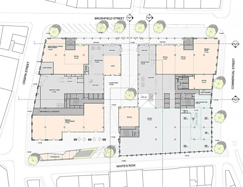
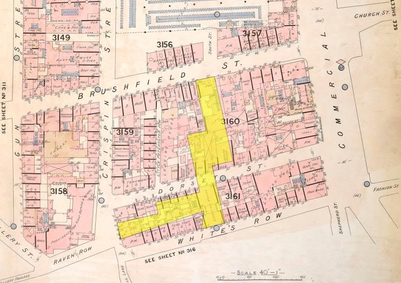
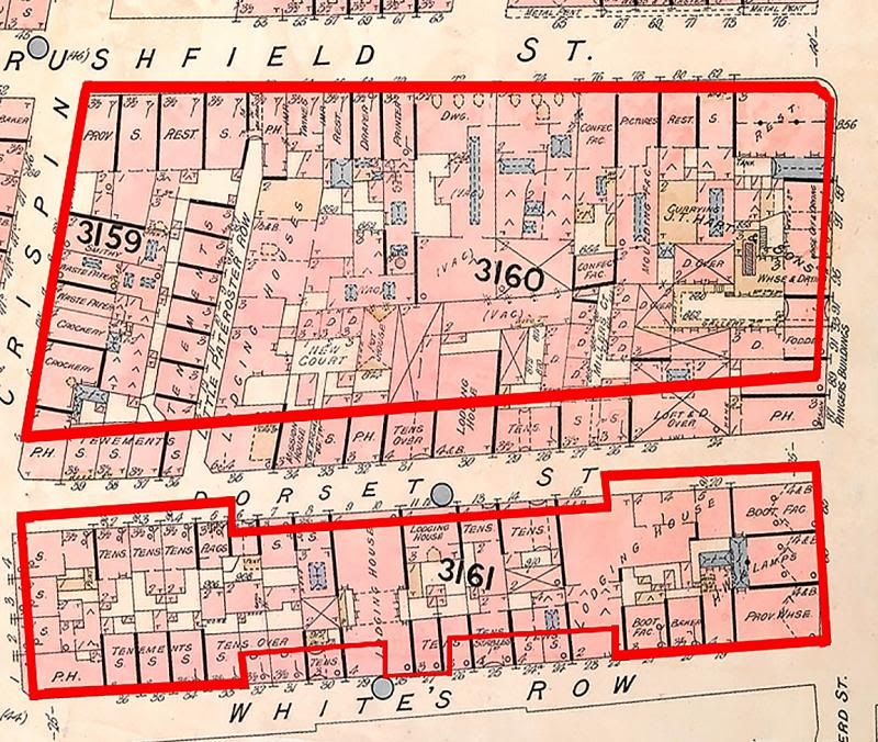
        In producing the following illustrations I calculated the scale using buildings known to be extant in 1888 which are still there today. Namely, 5 White's Row, Christ Church, the block of buildings on the east side of Commercial Street between Fashion Street and Christ Church burial ground and the south eastern part of Spitalfields market.


        The developer's plan.


        The new walk overlayed on the 1890 map.


        How the current buildings sit on the 1890 map.
        Post Tenebras Lux

        Comment


        • #5
          This has probably been done, but in the event that it hasn't, can someone post the exact latitude longitude coordinates (e.g., Google Earth) for each Ripper victim? It would be great if this info was on the Victim pages (as well as the coordinates of their gravesites). That way, no matter how much the area changes over the next thousand years or so (most likely this will still be a whodunit!), future sleuths will be able to pin down the exact locations.
          Last edited by Barnaby; 05-18-2014, 10:43 PM.

          Comment


          • #6
            Thanks, Hutch. A really interesting exercise.
            I won't always agree but I'll try not to be disagreeable.

            Comment


            • #7
              Yes Hutch, thanks indeed for taking the trouble

              Until you produced this I honestly couldn't envision it at all in 1888 terms

              Cheers

              Dave

              Comment


              • #8
                A good idea Barnaby. You can never tell what will happen to the area in the future. Removed as we are in time from the crimes we at least have basically the same street layouts and a few surviving buildings. Future Ripperologists may say about us "If only they'd documented the precise locations before Emperor Johnson covered everything up with his glass and steel offices!"

                We have Leonard Matters to thank for his photographs and descriptions of the area in 1928 when there was very little interest amongst the general public in the Whitechapel murders. This was 40 years after the events but oh, how I wish he'd taken more photos and followed the "dreadful looking slattern" , as he describes her, down the alley to take some photos in Miller's Court itself.

                The only trouble with using online resources like Google Earth is, that from what I can gather from people who know far more than me about these things, that the co-ordinates can be up to 10 metres out or even more. The same goes for civilian Sat Navs. So it's not just a matter of going to the sites and taking a reading either.

                Someone out there may well know the answer.
                Post Tenebras Lux

                Comment


                • #9
                  G'day Barnaby

                  But where to store them?

                  Not misunderstand me I'd love to have them if I ever get there but how to record them so someone can use them in say 200 years time.
                  G U T

                  There are two ways to be fooled, one is to believe what isn't true, the other is to refuse to believe that which is true.

                  Comment

                  Working...
                  X