Announcement

Collapse
No announcement yet.

Seeking Little Alie St information (and a long hello)

Collapse
X
 
  • Filter
  • Time
  • Show
Clear All
new posts

  • Colin Roberts
    replied
    Originally posted by byghostlight View Post
    thanks Colin ...
    You are most welcome.

    Originally posted by Roy Corduroy View Post
    While you are technically correct, 'Matfelon' was used, ...
    I have seen many instances of its use, during the Victorian era, Roy.

    But, I would argue with utmost conviction that each of them was colloquial.

    Even in cases of documentation that would seemingly have called for 'official', if not completely 'formal' usage, such as the one, which you have cited, above; I would contend, with the same degree of conviction, that any reference to 'Matfelon' was neither 'official', nor 'formal', but indeed 'colloquial'.

    On the basis of everything that I have been able to gather, thus far, I am thoroughly convinced that the St. Dunstan Stepney Chapel of Ease that came to be known as the 'White Chapel', was dedicated to 'St. Mary Matfelon'¹; but, that upon its consecration as a Parish Church, in ~1329, it was rededicated - simply - to 'St. Mary', and accordingly consecrated, as the 'Parish Church of St. Mary Whitechapel'.

    ¹Matfelon being, presumably, the name a major benefactor of the chapel.

    If the 'Matfelon' tag was not dropped upon the church's 1329 consecration, then it was most certainly dropped before the onset of the nineteenth century. Of that, I am certain!

    Even so, I am inclined to believe that there was never a Parish, or Parish Church, ... of 'St. Mary Matfelon Whitechapel'.

    While my inclination is based upon a variety of Parish Baptismal & Matrimonial Registers, Parish Boundary Markers, Census Records, tabulated Census Reports, etc ...; its single most significant basis is the multitude of Ordnance Surveys, and other similar cartographic sources of information, that we are fortunate enough to have at our disposal.

    The 1870's series and 1890's series of the Ordnance Survey both clearly delineate an abundance of Parishes of ... St. Mary Something-or-Other Some-Place-or-Other:

    St. Mary Abbotts Kennsington
    St. Mary Stratford Bow
    St. Mary Magdalen Bermondsey
    St. Mary Magdalen Woolwich
    St. Mary Aldermary (City of London)
    St. Mary Mounthaw (City of London)
    St. Mary Somerset (City of London)
    St. Mary Colechurch (City of London)
    St. Mary le Bow (City of London)
    St. Mary Bothaw (City of London)
    St. Mary Woolnoth (City of London)
    Etc ...

    But, in the case of Whitechapel: "St. Mary Whitechapel", i.e. no mention of 'Matfelon'.

    However, ...

    In the 'Large Scale' versions, of each series, the Parish Church of St. Mary Whitechapel is labeled:

    St. Mary's Church
    Site of
    White Chapel
    or
    St. Mary Matfelon

    I believe that we can gather a great deal from that description.

    ~~~

    Originally posted by Colin Roberts View Post
    Personally, I would not use the 'Matfelon' tag, ...
    You know how I go about my business, Roy.

    I believe that colloquialisms can be extremely misleading, in the context of Victorian London's political geography.

    Admittedly, the use of the 'Matfelon' tag is not going to cause any confusion, as might the Pall Mall Gazette's use of "Fulham Workhouse", i.e. an abbreviated form of the colloquial 'Fulham Road Workhouse', in reference to ...

    Originally posted by Colin Roberts View Post
    The St. George Hanover Square Union Workhouse, Fulham Road, Parish of St. Luke Chelsea: The so-called 'Fulham Road Workhouse'

    ...

    The Pall Mall Gazette references, ...

    ... to "Fulham Workhouse" are very misleading.

    They would suggest, more or less, that prior to his admissions thereto, and upon his discharges therefrom, Grainger was spending his time in the vicinity of 'Fulham'.

    However, I am inclined to believe that he was probably spending that time in the City of Westminster, in the vicinity of 'Millbank'.
    But, in any case, I believe that the use of colloquialisms, in the context of Victorian London's political geography, should be avoided, whenever doing so would be practical.
    Last edited by Colin Roberts; 07-04-2011, 02:13 AM.

    Leave a comment:


  • Roy Corduroy
    replied
    Good afternoon Colin,

    Originally posted by Colin Roberts View Post
    Personally, I would not use the 'Matfelon' tag, in reference to either the Parish or Parish Church of St. Mary Whitechapel.

    On the basis of everything that I have been able to gather, thus far; I am thoroughly convinced that it was merely a colloquial - and, therefore, technically incorrect - carryover, from the dedication of the Chapel of Ease, i.e. the 'White Chapel', that belonged to the Ancient Parish of St. Dunstan Stepney, until its consecration, in ~1329, as the Parish Church of St. Mary Whitechapel.
    While you are technically correct, 'Matfelon' was used, such as in this excerpt from page 21 of The Religious Census of London, 1888.

    Click image for larger version

Name:	StMary.jpg
Views:	1
Size:	76.1 KB
ID:	662457

    Gives morning & evening attendance. From archive.org (here) - Roy

    Leave a comment:


  • byghostlight
    replied
    thanks Colin for your wealth of knowledge, it certainly answered my question and a few others i didn't realise i had. i love that these forums have a wealth of people all with there own specialised areas who are willing to help. im currently lost deep in the world East End theatre history now there is a wealth of information available on the interweb these days!

    and cheers Lechmere for the Booth link, a great read, i have been using the maps but hadnt got around to looking through the document scans yet. There so isnt the hours in the day to read everything i want currently... hehe
    Last edited by byghostlight; 07-03-2011, 04:46 AM.

    Leave a comment:


  • byghostlight
    replied
    Originally posted by The Grave Maurice View Post
    See, bgl? Told ya: Colin is the man.
    Please let us know when your book is available. I was rearranging my bookshelves this afternoon and noticed that I have room for one more.
    yes he certain is!

    Thanks for the interest in the book, the way things are going it will be a while but after i find time to do an edit i will post an introduction. Its a self contained chapter that is like a birds eye though the area and history, inside the theatre, meet the main characters. It touches on the themes and teases the mysteries involved. Its about 10 odd pages long.

    Leave a comment:


  • The Grave Maurice
    replied
    See, bgl? Told ya: Colin is the man.
    Please let us know when your book is available. I was rearranging my bookshelves this afternoon and noticed that I have room for one more.

    Leave a comment:


  • Colin Roberts
    replied
    Originally posted by Robert View Post
    In both 1881 and 1891, Little Alie St is in the civil parish of Whitechapel, ...
    As was the case, in 1331, 1341, 1351, ..., and 1901, Robert.

    Leave a comment:


  • Colin Roberts
    replied
    Originally posted by byghostlight View Post
    hi Colin, i have seen the boundaries on some map i saw a while back and that bit of knowledge was unimportant at the time but naturally now i need it i cant remember where

    basically i have been trying to understand the boundaries between Christchurch, St Mary's Matfelon and St Georges-in-the-East and where Alie Street fits in.

    I was on St Georges amazing website and it seemed historical to be part of their parish but given its location thought it would come under St Marys?
    The Bottom Line:

    Little Alie Street was situated, quite comfortably, within the boundaries of the Civil Parish of St. Mary Whitechapel.

    ~~~

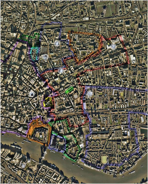
    The Whitechapel Registration District: A sort of 'Greater Whitechapel'


    Whitechapel Registration District / Poor Law Union: 1888 (Click Image, to Enlarge in flickr)
    Underlying Aerial Imagery: Copyright Google Earth, 2007
    Overlying Plots, Labels and Color-Shadings: Copyright Colin C. Roberts, 2010

    Whitechapel Registration District / Poor Law Union (Populations, in Accordance with the Census of England & Wales, 1891):
    - The Liberty of Norton Folgate (Green): 1,449
    - The Old Artillery Ground (Aqua): 2,138
    - The Parish of Christ Church Spitalfields (Blue): 22,859
    - The Hamlet of Mile End New Town (Orange): 11,303
    - The Parish of Holy Trinity ('Minories') (Yellow): 301
    - The Parish of St. Mary Whitechapel (Red): 32,326
    ----- {Portion within the County of Middlesex, -1889; ... the County of London, 1889-1965: 32,284}
    ----- {Portion within the City of London, -1900: 42}
    - The Liberty of Her Majesty's Tower of London (Orange): 933
    ----- {The Liberty of the Tower: n/a}
    ----- {The Precinct of Old Tower Without: 65}
    ----- {The Tower: 868}
    - The Precinct of St. Katharine (Blue): 182
    - The Parish of St. Botolph without Aldgate (Green): 2,971
    ----- {Portion within the County of Middlesex, -1889; ... the County of London, 1889-1965: 2,971}

    The portion of the Parish of St. Mary Whitechapel (42) that was situated within the Municipality of the City of London, was a component of the Whitechapel Registration District / Poor Law Union; until becoming a part of the Parish of St. Botolph without Aldgate, City of London, in 1900; and accordingly being then included within the Registration / Poor Law administration of the City of London.

    - Total Population - Whitechapel Registration District / Poor Law Union (In Accordance with the Census of England & Wales, 1891): 74,462


    ~~~


    City of London Registration District / Poor Law Union (In Minor Part); Whitechapel Registration District / Poor Law Union (In Entirety); St. George in the East Registration District / Poor Law Parish (In Major Part): 1888 (Click Image, to Enlarge in flickr)
    Underlying Aerial Imagery: Copyright Google Earth, 2007
    Overlying Plots, Labels and Color-Shadings: Copyright Colin C. Roberts, 2010

    This image includes the additions of the City of London (in minor part) (purple); Little Alie Street, Parish of St. Mary Whitechapel (green); and the Parish of St. George in the East (in major part) (blue).

    Incidentally, the green dot that appears in both images, is the murder-site mean-center, i.e. the 'average' of those murder-sites, which are most widely associated with the mystery of 'Jack the Ripper': Tabram, Nichols, Chapman, Stride, Eddowes, and Kelly.

    City of London Registration District / Poor Law Union (Population, in Accordance with the Census of England & Wales, 1891):
    - All Applicable Parochial and Extra-Parochial Constituencies: 38,320

    St. George in the East Registration District / Poor Law Parish (Population, in Accordance with the Census of England & Wales, 1891):
    - The Parish of St. George in the East: 45,795

    - The area that is situated directly north of the City of London and the Liberty of Norton Folgate, constituted, more-or-less, a portion of the Parish of St. Leonard Shoreditch.

    - The area that is situated directly north of the Parish of Christ Church Spitalfields, the Hamlet of Mile End New Town, and the Parish of St. Mary Whitechapel, constituted, more-or-less, a portion of the Parish of St. Matthew Bethnal Green.

    - The area that is situated along the northeastern edge of the image, and which extends westward, between the Parish of St. Mary Whitechapel and the Parish of St. George in the East, constituted, more-or-less, a portion of the Hamlet of Mile End Old Town.

    - The area that is situated along the southeastern boundary of the Parish of St. George in the East, constituted, more-or-less, a portion of the Parish of St. Paul Shadwell.

    - The area that is situated along the southern and southwestern boundaries of the Parish of St. George in the East, constituted the entirety of the Parish of St. John of Wapping.

    ~~~

    Because of their close proximity to St. Mary's Church, i.e. the Parish Church of St. Mary Whitechapel; the western-most reaches of the Hamlet of Mile End Old Town, and the northwestern-most reaches of the Parish of St. George in the East were colloquially referred to as 'Whitechapel'.

    ~~~

    Originally posted by byghostlight View Post
    St Mary's Matfelon
    Personally, I would not use the 'Matfelon' tag, in reference to either the Parish or Parish Church of St. Mary Whitechapel.

    On the basis of everything that I have been able to gather, thus far; I am thoroughly convinced that it was merely a colloquial - and, therefore, technically incorrect - carryover, from the dedication of the Chapel of Ease, i.e. the 'White Chapel', that belonged to the Ancient Parish of St. Dunstan Stepney, until its consecration, in ~1329, as the Parish Church of St. Mary Whitechapel.

    Leave a comment:


  • Robert
    replied
    Hi Ghost

    In both 1881 and 1891, Little Alie St is in the civil parish of Whitechapel, and the ecclesiastical parish of St Marks.

    Leave a comment:


  • Lechmere
    replied
    I came across this while looking for something else:


    It is the notes taken as part of Charles Booth’s poverty investigation, while being shown around by Inspector Reid in 1898.

    Leave a comment:


  • byghostlight
    replied
    hi Colin, i have seen the boundaries on some map i saw a while back and that bit of knowledge was unimportant at the time but naturally now i need it i cant remember where

    basically i have been trying to understand the boundaries between Christchurch, St Mary's Matfelon and St Georges-in-the-East and where Alie Street fits in.

    I was on St Georges amazing website and it seemed historical to be part of their parish but given its location thought it would come under St Marys?

    Leave a comment:


  • byghostlight
    replied
    thanks Roy for the extract, i have been slowly working through that link as well and the picture of Marie Lloyd was also a nice touch

    Leave a comment:


  • Robert
    replied
    Thanks Roy - and David.

    Leave a comment:


  • Roy Corduroy
    replied
    Originally posted by Robert View Post
    Hi Roy

    Where did you get the 1888 directory from?
    Right here on Casebook from the kind Mr. Proto-Dave

    Discussion for general Whitechapel geography, mapping and routes the killer might have taken. Also the place for general census information and "what was it like in Whitechapel" discussions.


    Try post #52. Seems to still work.

    Roy

    Leave a comment:


  • Colin Roberts
    replied
    Originally posted by The Grave Maurice View Post
    As to your question #4, I believe that parish boundary maps are on this site somewhere; however, with any luck, Colin Roberts will see this thread and give you all the information you need.
    Thanks, Ken!

    Parish boundaries are clearly delineated, on both the 1870's series, and 1890's series Ordnance Surveys.

    However, they are much more easily distinguishable, on the 1870's series.

    In any case, byghostlight, how may I be of assistance?

    Leave a comment:


  • Robert
    replied
    Hi Roy

    Where did you get the 1888 directory from?

    Leave a comment:

Working...
X