Announcement

Collapse
No announcement yet.

London vs. Whitechaple being in "the grip of fear"

Collapse
X
 
  • Filter
  • Time
  • Show
Clear All
new posts

  • London vs. Whitechaple being in "the grip of fear"

    Hello, all. I'm a new member here, and am trying to get some perspective on London in 1888, to put the Ripper events in context.

    So...I have read (not necessarily here) generalities about London being terrified by the Whitechapel murders, the "Autumn of Terror," etc....but did London at large really feel put at personal risk by the murders happening in the slum of Whitechapel? I wouldn't think the general public would feel any identification with the "fallen women" who were the victims, and how many Londoners routinely went into that area, anyway?

    I'm kind of unclear as to the layout of London in that era, which I guess bordered Whitechapel, which wasn't even part of London proper.

    This map on the site (http://casebook.org/images/rippernotes/poverty_map.jpg) looks like a good place for me to start as to orientation, but it looks like nicer dwellings were also found in Whitechapel (??) Who lived there besides the lowest-of-the-economic-low?

    Thanks for your indulgance as I try to get a grasp on that area, etc.

  • #2
    Originally posted by Merry_Olde_Mary View Post
    ..., but it looks like nicer dwellings were also found in Whitechapel (??) Who lived there besides the lowest-of-the-economic-low?
    The Whitechapel Registration District: A sort of 'Greater Whitechapel'


    Whitechapel Registration District / Poor Law Union - 1888 (Click Image, to Enlarge in flickr)
    Underlying Aerial Imagery: Copyright Google Earth, 2007
    Overlying Plots, Labels and Color-Shadings: Copyright Colin C. Roberts, 2010

    Whitechapel Registration District / Poor Law Union (Populations, in Accordance with the Census of England & Wales, 1891):
    - The Liberty of Norton Folgate (Green): 1,449
    - The Old Artillery Ground (Aqua): 2,138
    - The Parish of Christ Church Spitalfields (Blue): 22,859
    - The Hamlet of Mile End New Town (Orange): 11,303
    - The Parish of Holy Trinity ('Minories') (Yellow): 301
    - The Parish of St. Mary Whitechapel (Red): 32,326
    ----- {Portion within the County of Middlesex, -1889; ... the County of London, 1889-1965: 32,284}
    ----- {Portion within the City of London, -1900: 42}
    - The Liberty of Her Majesty's Tower of London (Orange): 933
    ----- {The Liberty of the Tower: n/a}
    ----- {The Precinct of Old Tower Without: 65}
    ----- {The Tower: 868}
    - The Precinct of St. Katharine (Blue): 182
    - The Parish of St. Botolph without Aldgate (Green): 2,971
    ----- {Portion within the County of Middlesex, -1889; ... the County of London, 1889-1965: 2,971}

    The portion of the Parish of St. Mary Whitechapel (42) that was situated within the Municipality of the City of London, was a component of the Whitechapel Registration District / Poor Law Union; until becoming a part of the Parish of St. Botolph without Aldgate, City of London, in 1900; and accordingly being then included within the Registration / Poor Law administration of the City of London.

    - Total Population - Whitechapel Registration District / Poor Law Union (In Accordance with the Census of England & Wales, 1891): 74,462


    ---


    Whitechapel Registration District; as Depicted in Charles Booth's Descriptive Map of London Poverty, 1887-1889 (Click Image, to Enlarge in flickr)

    Charles Booth's Socio-Economic Classifications

    Below the 'Line of Poverty'
    - Class A: Lowest Class; 'Vicious' (i.e. vice-ridden), 'Semi-Criminal'
    - Class B: Very Poor; 'Casual' (i.e. day-to-day) Income
    - Class C: Poor; Intermittent Income
    - Class D: Poor; Regular, but, Inadequate Income

    Above the 'Line of Poverty'
    - Class E: Working Class; Regular Income
    - Class F: Upper Working Class; Skilled Labour
    - Class G: Lower Middle Class
    - Class H: Upper Middle Class


    ---

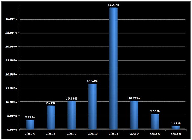
    Distribution of Charles Booth's Socio-Economic Classifications, Whitechapel Registration District / Poor Law Union, 1889

    Below the 'Line of Poverty'
    - Class A: 2,487 / 3.38%
    - Class B: 6,333 / 8.61%
    - Class C: 7,525 / 10.24%
    - Class D: 12,157 / 16.54%

    - Sub-Total: 28,502 / 38.77%

    Above the 'Line of Poverty'
    - Class E: 32,501 / 44.21%
    - Class F: 7,560 / 10.28%
    - Class G: 4,087 / 5.56%
    - Class H: 868 / 1.18%

    - Sub-Total: 45,016 / 61.23%

    - Total: 73,518 / 100.00%


    Distribution of Charles Booth's Socio-Economic Classifications: Whitechapel Registration District / Poor Law Union, 1889 (Click Image, to Enlarge in flickr)


    Distribution of Charles Booth's Socio-Economic Classifications: Whitechapel Registration District / Poor Law Union, 1889 (Click Image, to Enlarge in flickr)

    ---

    "Who lived there besides the lowest-of-the-economic-low?"

    Contrary to conventional misconception; London's 'East End', of 1888, was not a vast landscape of abject poverty.

    Rather; it was a vast landscape of 'blue-collar' working class society that was burdened with, perhaps, slightly more than its fair share of enclaves, of abject poverty.

    Whitechapel was no exception.

    Incidentally; the greatest concentrations of London's poverty, in 1888, were found, not in the 'East End', but south of the River Thames, in the so-called 'Bankside' portions of the Borough of Southwark, and the adjoining western-most reaches of the Parish of St. Mary Magdalen Bermondsey.

    Comment


    • #3
      Oh boy, Colin....a case of "be careful what you ask for"!!! Great attachments I'll have to study!

      The "dissertation" area of this site with all the articles and essays is GREAT! I've been picking through it, and gleaning more info about the area of Whitechapel. These are some things I got so far:
      • Whitechapel's an old, main road going into London, so there were many taverns and pubs there to house travelers, coachmen etc. So I guess in addition to the residents, there was a constant stream of visitors coming in and out.
      • For some reason, a livestock slaughter industry sprang up there centuries before (?) 1880. Very creepy that there were animal carcases swinging about in spots. I guess that's why there's so much mention in different essays that the Ripper could have learned some surgery skills from dissecting meat...there were many butchers living and working in the district. That is also why he might have had cutting tools. (I know everyone else knows all this, I'm just reviewing what I read.)
      • "Petticoat Lane", whose name has always been an odd mystery to me, is called that because it was where there were miles of used clothing resale shops. The wares would be hung up and laid out in front of the shops, so looking down the street one saw blocks and blocks and blocks of clothing, or petticoats, displayed for sale.
      • There was an old bell foundry out there that manufactured big iron bells. I guess that's why there was also a local bar called The Four Bells.
      • There were some decent residences in Whitechapel.....though some of these old, nicer buildings had also been converted into boarding houses.
      • The influx of foreign Jews may have been viewed with hostility and placed low on the local pecking order, but they actually improved their areas and tried to keep things (comparatively) clean. (Or at least, I think there was something along those lines.) Ironic, and horrible, that they were vilified when they were actually improving the neighborhood.

      Thanks for your extensive answer and data! I'll look it all over carefully : )
      Last edited by Merry_Olde_Mary; 06-05-2011, 05:00 AM.

      Comment

      Working...
      X