
 Tweet
Tweet
Prostitution and Charles Booth's Socio-Economic Classifications
I have often felt that the term 'East End Prostitute' was perhaps somewhat misleading. Was there really such a 'genus' - so to speak - in London's eastern quarter, during the Victorian era? Or was the 'East End' much too large, much too heavily populated, and much too diverse to accommodate a widely distributed species of such presumable homogeneity?
I am quite convinced that prostitutes of London's 'East End' came in all shapes and sizes, and offered a wide variety of 'services', in the latter part of the nineteenth century; and that the manners, in which they conducted themselves, involved very few 'common denominators' that we today could describe as having been 'typical'.
The following exercise is an attempt to estimate the number of prostitutes that resided in London's 'East End', during the so-called 'Autumn of Terror'; by way of a perceived manner of distribution, across the spectrum of Charles Booth's socio-economic classifications.
...
Charles Booth's delineations of socio-economic classification …
"In Poverty":
Class 'A': "Vicious" (i.e. vice-ridden); "Semi-Criminal"
Class 'B': "Very Poor"
Class 'C': "Poor" - Irregular Income
Class 'D': "Poor" - Regular but Inadequate Income
"In Comfort":
Class 'E': "Above the 'Line of Poverty'" - Regular "Standard" Income
Class 'F': "Highly Skilled Labour"
Class 'G': "Lower Middle-Class"
Class 'H': "Upper Middle-Class"
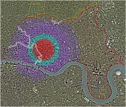
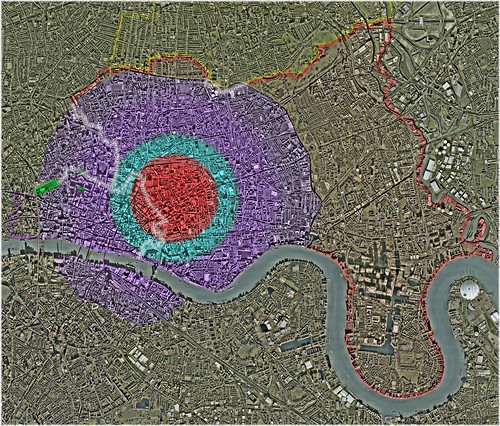
A graphic depiction …

Estimated Number of Prostitutes, In Proportion to the Estimated Number of Females (Ages 12-to-59), Within Each of Charles Booth's Delineations of Socio-Economic Class – The Parliamentary Borough of Tower Hamlets (1889-1891) (Click to Enlarge in flickr)
Backdrop: London's 'East End' – 1888
Underlying Aerial Imagery: Copyright Google Earth, 2007
Overlying Plots, Labels and Color-Shadings: Copyright Colin C. Roberts, 2009
… of the following estimations:
The Parliamentary Borough of Tower Hamlets:
Total Population - Female; Ages 12-to-59 (1891 Census): ~141,852
- Class 'A': 1,360 Prostitutes; From Amongst 2,039 Females (Ages 12-to-59)
- Class 'B': 5,398 Prostitutes; From Amongst 16,194 Females (Ages 12-to-59)
- Classes 'C' & 'D': 5,454 Prostitutes; From Amongst 32,723 Females (Ages 12-to-59)
Sub-Total (Below the 'Line of Poverty'): 12,211 Prostitutes; From Amongst 50,956 Females (Ages 12-to-59)
- Classes 'E' & 'F': 6,927 Prostitutes; From Amongst 83,120 Females (Ages 12-to-59)
- Classes 'G' & 'H': 324 Prostitutes; From Amongst 7,776 Females (Ages 12-to-59)
Sub-Total (Above the 'Line of Poverty'): 7,251 Prostitutes; From Amongst 90,896 Females (Ages 12-to-59)
Total: 19,462 Prostitutes; From Amongst 141,852 Females (Ages 12-to-59)
Put Simply:
I have estimated that the Parliamentary Borough of Tower Hamlets was inhabited by 141,852 females, between the ages of 12 and 59, in 1891; and that …
- 2,039 exhibited characteristics of Charles Booth's Class 'A'; with as many as 1,360 being prostitutes
- 16,194 exhibited characteristics of Charles Booth's Class 'B'; with as many as 5,398 being prostitutes
- 32,723 exhibited characteristics of Charles Booth's Classes 'C' & 'D'; with as many as 5,454 being prostitutes
- 83,120 exhibited characteristics of Charles Booth's Classes 'E' & 'F'; with as many as 6,927 being prostitutes
- 7,776 exhibited characteristics of Charles Booth's Classes 'G' & 'H'; with as many as 324 being prostitutes
... Or, More Simply:
I have estimated that the Parliamentary Borough of Tower Hamlets was inhabited by 141,852 females, between the ages of 12 and 59, in 1891; with as many as 19,462 (i.e. 13.72%) having been prostitutes:
- 1,360 exhibiting characteristics of Charles Booth's Class 'A'
- 5,398 exhibiting characteristics of Charles Booth's Class 'B'
- 5,454 exhibiting characteristics of Charles Booth's Class 'C' & 'D'
- 6,927 exhibiting characteristics of Charles Booth's Class 'E' & 'F'
- 324 exhibiting characteristics of Charles Booth's Class 'G' & 'H'
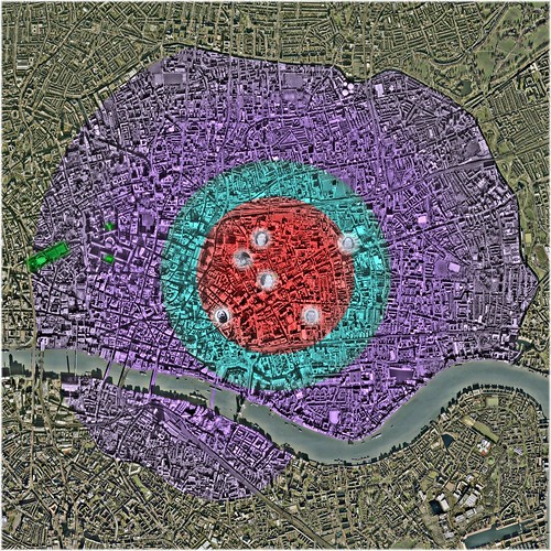
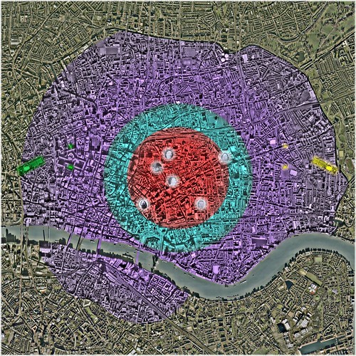
A graphic depiction …

Estimated Number of Prostitutes, In Proportion to the Estimated Number of Females (Ages 12-to-59), Within Each of Charles Booth's Delineations of Socio-Economic Class – London's 'East End' (1889-1891) (Click to Enlarge in flickr)
Backdrop: London's 'East End' – 1888
Underlying Aerial Imagery: Copyright Google Earth, 2007
Overlying Plots, Labels and Color-Shadings: Copyright Colin C. Roberts, 2009
… of the following estimations:
London's 'East End':
The Parliamentary Boroughs of Shoreditch, Bethnal Green, and Tower Hamlets
Total Population - Female; Ages 12-to-59 (1891 Census): ~223,490
- Class 'A': 1,967 Prostitutes; From Amongst 2,950 Females (Ages 12-to-59)
- Class 'B': 8,850 Prostitutes; From Amongst 26,549 Females (Ages 12-to-59)
- Classes 'C' & 'D': 9,319 Prostitutes; From Amongst 55,911 Females (Ages 12-to-59)
Sub-Total (Below the 'Line of Poverty'): 20,135 Prostitutes; From Amongst 85,410 Females (Ages 12-to-59)
- Classes 'E' & 'F': 10,598 Prostitutes; From Amongst 127,179 Females (Ages 12-to-59)
- Classes 'G' & 'H': 454 Prostitutes; From Amongst 10,901 Females (Ages 12-to-59)
Sub-Total (Above the 'Line of Poverty'): 11,052 Prostitutes; From Amongst 138,080 Females (Ages 12-to-59)
Total: 31,187 Prostitutes; From Amongst 223,490 Females (Ages 12-to-59)
Put Simply:
I have estimated that London's 'East End' was inhabited by 223,490 females, between the ages of 12 and 59, in 1891; and that …
- 2,950 exhibited characteristics of Charles Booth's Class 'A'; with as many as 1,967 being prostitutes
- 26,549 exhibited characteristics of Charles Booth's Class 'B'; with as many as 8,850 being prostitutes
- 55,911 exhibited characteristics of Charles Booth's Classes 'C' & 'D'; with as many as 9,319 being prostitutes
- 127,179 exhibited characteristics of Charles Booth's Classes 'E' & 'F'; with as many as 10,598 being prostitutes
- 10,901 exhibited characteristics of Charles Booth's Classes 'G' & 'H'; with as many as 454 being prostitutes
... Or, More Simply:
I have estimated that London's 'East End' was inhabited by 223,490 females, between the ages of 12 and 59, in 1891; with as many as 31,187 (i.e. 13.95%) having been prostitutes:
- 1,967 exhibiting characteristics of Charles Booth's Class 'A'
- 8,850 exhibiting characteristics of Charles Booth's Class 'B'
- 9,319 exhibiting characteristics of Charles Booth's Class 'C' & 'D'
- 10,598 exhibiting characteristics of Charles Booth's Class 'E' & 'F'
- 454 exhibiting characteristics of Charles Booth's Class 'G' & 'H'
...
That was, more-or-less, the 'Bottom Line'. The process, by which these estimations were derived, is as follows …
The 'Pool': Females; Ages 12-to-59
The Parliamentary Borough of Tower Hamlets
Whitechapel Registration District / Poor Law Union:
- The Liberty of Norton Folgate
- The Old Artillery Ground
- The Parish of Christ Church Spitalfields
- The Hamlet of Mile End New Town
- The Parish of Holy Trinity ('Minories')
- The Parish of St. Mary Whitechapel (portion within the County of Middlesex, -1889; the County of London, 1889-1965)
- The Liberty of Her Majesty's Tower of London
--- {The Liberty of the Tower}
--- {The Precinct of Old Tower Without}
--- {The Tower}
- The Precinct of St. Katharine
- The Parish of St. Botolph without Aldgate (portion within the County of Middlesex, -1889; the County of London, 1889-1965)
- Total Population (1891 Census): 74,462
- Total Population (Charles Booth 1889 Estimate): 73,518
- Percentage of Total Population Living Below the 'Line of Poverty' (Charles Booth 1889 Estimate): 39.20%
- Percentage of Total Population Living Above the 'Line of Poverty' (Charles Booth 1889 Estimate): 60.80%
- Total Population - Male (1891 Census): 38,935
- Total Population - Female (1891 Census): 35,527
- Total Population - Female; Ages 10-to-14 (1891 Census): 3,538
- Total Population - Female; Ages 15-to-19 (1891 Census): 3,709
- Total Population - Female; Ages 20-to-24 (1891 Census): 3,920
- Total Population - Female; Ages 25-to-29 (1891 Census): 3,219
- Total Population - Female; Ages 30-to-34 (1891 Census): 2,550
- Total Population - Female; Ages 35-to-39 (1891 Census): 2,044
- Total Population - Female; Ages 40-to-44 (1891 Census): 1,838
- Total Population - Female; Ages 45-to-49 (1891 Census): 1,473
- Total Population - Female; Ages 50-to-54 (1891 Census): 1,289
- Total Population - Female; Ages 55-to-59 (1891 Census): 894
- Total Population - Female; Ages 10-to-59 (1891 Census): 24,474
- Total Population - Female; Ages 12-to-59 (1891 Census): ~23,059*
* Figure for 'Ages 10-to-14' reduced by 40 percent.
Mile End Old Town Registration District / Poor Law Parish:
- The Hamlet of Mile End Old Town
- Total Population (1891 Census): 107,592
- Total Population (Charles Booth 1889 Estimate): 110,321
- Percentage of Total Population Living Below the 'Line of Poverty' (Charles Booth 1889 Estimate): 26.20%
- Percentage of Total Population Living Above the 'Line of Poverty' (Charles Booth 1889 Estimate): 73.80%
- Total Population - Male (1891 Census): 52,340
- Total Population - Female (1891 Census): 55,252
- Total Population - Female; Ages 10-to-14 (1891 Census): 5,729
- Total Population - Female; Ages 15-to-19 (1891 Census): 5,326
- Total Population - Female; Ages 20-to-24 (1891 Census): 5,431
- Total Population - Female; Ages 25-to-29 (1891 Census): 4,734
- Total Population - Female; Ages 30-to-34 (1891 Census): 3,850
- Total Population - Female; Ages 35-to-39 (1891 Census): 3,257
- Total Population - Female; Ages 40-to-44 (1891 Census): 2,962
- Total Population - Female; Ages 45-to-49 (1891 Census): 2,530
- Total Population - Female; Ages 50-to-54 (1891 Census): 2,141
- Total Population - Female; Ages 55-to-59 (1891 Census): 1,585
- Total Population - Female; Ages 10-to-59 (1891 Census): 37,545
- Total Population - Female; Ages 12-to-59 (1891 Census): ~35,253*
* Figure for 'Ages 10-to-14' reduced by 40 percent.
St. George in the East Registration District / Poor Law Parish:
- The Parish of St. George in the East
- Total Population (1891 Census): 45,795
- Total Population (Charles Booth 1889 Estimate): 47,578
- Percentage of Total Population Living Below the 'Line of Poverty' (Charles Booth 1889 Estimate): 48.80%
- Percentage of Total Population Living Above the 'Line of Poverty' (Charles Booth 1889 Estimate): 51.20%
- Total Population - Male (1891 Census): 23,096
- Total Population - Female (1891 Census): 22,699
- Total Population - Female; Ages 10-to-14 (1891 Census): 2,277
- Total Population - Female; Ages 15-to-19 (1891 Census): 2,112
- Total Population - Female; Ages 20-to-24 (1891 Census): 2,194
- Total Population - Female; Ages 25-to-29 (1891 Census): 1,983
- Total Population - Female; Ages 30-to-34 (1891 Census): 1,624
- Total Population - Female; Ages 35-to-39 (1891 Census): 1,311
- Total Population - Female; Ages 40-to-44 (1891 Census): 1,204
- Total Population - Female; Ages 45-to-49 (1891 Census): 974
- Total Population - Female; Ages 50-to-54 (1891 Census): 942
- Total Population - Female; Ages 55-to-59 (1891 Census): 605
- Total Population - Female; Ages 10-to-59 (1891 Census): 15,226
- Total Population - Female; Ages 12-to-59 (1891 Census): ~14,315*
* Figure for 'Ages 10-to-14' reduced by 40 percent.
Stepney Registration District / Poor Law Union:
- The Parish of St. John of Wapping
- The Parish of St. Paul Shadwell
- The Hamlet of Ratcliff
- The Parish of St. Anne Limehouse
- Total Population (1891 Census): 57,376
- Total Population (Charles Booth 1889 Estimate): 62,063
- Percentage of Total Population Living Below the 'Line of Poverty' (Charles Booth 1889 Estimate): 38.10%
- Percentage of Total Population Living Above the 'Line of Poverty' (Charles Booth 1889 Estimate): 61.90%
- Total Population - Male (1891 Census): 29,403
- Total Population - Female (1891 Census): 27,973
- Total Population - Female; Ages 10-to-14 (1891 Census): 3,092
- Total Population - Female; Ages 15-to-19 (1891 Census): 2,751
- Total Population - Female; Ages 20-to-24 (1891 Census): 2,589
- Total Population - Female; Ages 25-to-29 (1891 Census): 2,246
- Total Population - Female; Ages 30-to-34 (1891 Census): 1,989
- Total Population - Female; Ages 35-to-39 (1891 Census): 1,708
- Total Population - Female; Ages 40-to-44 (1891 Census): 1,542
- Total Population - Female; Ages 45-to-49 (1891 Census): 1,294
- Total Population - Female; Ages 50-to-54 (1891 Census): 1,100
- Total Population - Female; Ages 55-to-59 (1891 Census): 801
- Total Population - Female; Ages 10-to-59 (1891 Census): 19,112
- Total Population - Female; Ages 12-to-59 (1891 Census): ~17,875*
* Figure for 'Ages 10-to-14' reduced by 40 percent.
Poplar Registration District / Poor Law Union:
- The Parish of St. Mary Stratford Bow
- The Parish of Bromley St. Leonard
- The Parish of All Saints Poplar
- Total Population (1891 Census): 166,748
- Total Population (Charles Booth 1889 Estimate): 166,393
- Percentage of Total Population Living Below the 'Line of Poverty' (Charles Booth 1889 Estimate): 36.50%
- Percentage of Total Population Living Above the 'Line of Poverty' (Charles Booth 1889 Estimate): 63.50%
- Total Population - Male (1891 Census): 84,302
- Total Population - Female (1891 Census): 82,446
- Total Population - Female; Ages 10-to-14 (1891 Census): 9,192
- Total Population - Female; Ages 15-to-19 (1891 Census): 7,674
- Total Population - Female; Ages 20-to-24 (1891 Census): 6,997
- Total Population - Female; Ages 25-to-29 (1891 Census): 6,640
- Total Population - Female; Ages 30-to-34 (1891 Census): 5,755
- Total Population - Female; Ages 35-to-39 (1891 Census): 5,040
- Total Population - Female; Ages 40-to-44 (1891 Census): 4,464
- Total Population - Female; Ages 45-to-49 (1891 Census): 3,774
- Total Population - Female; Ages 50-to-54 (1891 Census): 3,222
- Total Population - Female; Ages 55-to-59 (1891 Census): 2,268
- Total Population - Female; Ages 10-to-59 (1891 Census): 55,026
- Total Population - Female; Ages 12-to-59 (1891 Census): ~51,349*
* Figure for 'Ages 10-to-14' reduced by 40 percent.
Total - The Parliamentary Borough of Tower Hamlets:
- Total Population (1891 Census): 451,973
- Total Population (Charles Booth 1889 Estimate): 459,873
- Percentage of Total Population Living Below the 'Line of Poverty' (Charles Booth 1889 Estimate): 35.95%
- Percentage of Total Population Living Above the 'Line of Poverty' (Charles Booth 1889 Estimate): 64.05%
- Total Population - Male (1891 Census): 228,076
- Total Population - Female (1891 Census): 223,897
- Total Population - Female; Ages 10-to-14 (1891 Census): 23,828
- Total Population - Female; Ages 15-to-19 (1891 Census): 21,572
- Total Population - Female; Ages 20-to-24 (1891 Census): 21,131
- Total Population - Female; Ages 25-to-29 (1891 Census): 18,822
- Total Population - Female; Ages 30-to-34 (1891 Census): 15,768
- Total Population - Female; Ages 35-to-39 (1891 Census): 13,360
- Total Population - Female; Ages 40-to-44 (1891 Census): 12,010
- Total Population - Female; Ages 45-to-49 (1891 Census): 10,045
- Total Population - Female; Ages 50-to-54 (1891 Census): 8,694
- Total Population - Female; Ages 55-to-59 (1891 Census): 6,153
- Total Population - Female; Ages 10-to-59 (1891 Census): 151,383
- Total Population - Female; Ages 12-to-59 (1891 Census): ~141,852*
* Figure for 'Ages 10-to-14' reduced by 40 percent.
London's 'East End':
The Parliamentary Boroughs of Shoreditch, Bethnal Green, and Tower Hamlets
The Parliamentary Borough of Shoreditch
Shoreditch Registration District / Poor Law Parish:
- The Parish of St. Leonard Shoreditch
- Total Population (1891 Census): 124,009
- Total Population (Charles Booth 1889 Estimate): 121,161
- Percentage of Total Population Living Below the 'Line of Poverty' (Charles Booth 1889 Estimate): 40.20%
- Percentage of Total Population Living Above the 'Line of Poverty' (Charles Booth 1889 Estimate): 59.80%
- Total Population - Male (1891 Census): 60,790
- Total Population - Female (1891 Census): 63,219
- Total Population - Female; Ages 10-to-14 (1891 Census): 6,652
- Total Population - Female; Ages 15-to-19 (1891 Census): 6,002
- Total Population - Female; Ages 20-to-24 (1891 Census): 5,993
- Total Population - Female; Ages 25-to-29 (1891 Census): 5,293
- Total Population - Female; Ages 30-to-34 (1891 Census): 4,555
- Total Population - Female; Ages 35-to-39 (1891 Census): 4,183
- Total Population - Female; Ages 40-to-44 (1891 Census): 3,392
- Total Population - Female; Ages 45-to-49 (1891 Census): 2,823
- Total Population - Female; Ages 50-to-54 (1891 Census): 2,472
- Total Population - Female; Ages 55-to-59 (1891 Census): 1,803
- Total Population - Female; Ages 10-to-59 (1891 Census): 43,168
- Total Population - Female; Ages 12-to-59 (1891 Census): ~40,507*
* Figure for 'Ages 10-to-14' reduced by 40 percent.
The Parliamentary Borough of Bethnal Green
Bethnal Green Registration District / Poor Law Parish:
- The Parish of St. Matthew Bethnal Green
- Total Population (1891 Census): 129,132
- Total Population (Charles Booth 1889 Estimate): 127,641
- Percentage of Total Population Living Below the 'Line of Poverty' (Charles Booth 1889 Estimate): 44.70%
- Percentage of Total Population Living Above the 'Line of Poverty' (Charles Booth 1889 Estimate): 55.30%
- Total Population - Male (1891 Census): 63,308
- Total Population - Female (1891 Census): 65,824
- Total Population - Female; Ages 10-to-14 (1891 Census): 7,251
- Total Population - Female; Ages 15-to-19 (1891 Census): 6,743
- Total Population - Female; Ages 20-to-24 (1891 Census): 6,111
- Total Population - Female; Ages 25-to-29 (1891 Census): 5,147
- Total Population - Female; Ages 30-to-34 (1891 Census): 4,399
- Total Population - Female; Ages 35-to-39 (1891 Census): 3,986
- Total Population - Female; Ages 40-to-44 (1891 Census): 3,481
- Total Population - Female; Ages 45-to-49 (1891 Census): 2,784
- Total Population - Female; Ages 50-to-54 (1891 Census): 2,454
- Total Population - Female; Ages 55-to-59 (1891 Census): 1,675
- Total Population - Female; Ages 10-to-59 (1891 Census): 44,031
- Total Population - Female; Ages 12-to-59 (1891 Census): ~41,131*
* Figure for 'Ages 10-to-14' reduced by 40 percent.
Total - London's 'East End':
The Parliamentary Boroughs of Shoreditch, Bethnal Green, and Tower Hamlets
- Total Population (1891 Census): 705,114
- Total Population (Charles Booth 1889 Estimate): 708,675
- Percentage of Total Population Living Below the 'Line of Poverty' (Charles Booth 1889 Estimate): 38.00%
- Percentage of Total Population Living Above the 'Line of Poverty' (Charles Booth 1889 Estimate): 62.00%
- Total Population - Male (1891 Census): 352,174
- Total Population - Female (1891 Census): 352,940
- Total Population - Female; Ages 10-to-14 (1891 Census): 37,731
- Total Population - Female; Ages 15-to-19 (1891 Census): 34,317
- Total Population - Female; Ages 20-to-24 (1891 Census): 33,235
- Total Population - Female; Ages 25-to-29 (1891 Census): 29,262
- Total Population - Female; Ages 30-to-34 (1891 Census): 24,722
- Total Population - Female; Ages 35-to-39 (1891 Census): 21,529
- Total Population - Female; Ages 40-to-44 (1891 Census): 18,883
- Total Population - Female; Ages 45-to-49 (1891 Census): 15,652
- Total Population - Female; Ages 50-to-54 (1891 Census): 13,620
- Total Population - Female; Ages 55-to-59 (1891 Census): 9,631
- Total Population - Female; Ages 10-to-59 (1891 Census): 238,582
- Total Population - Female; Ages 12-to-59 (1891 Census): ~223,490*
* Figure for 'Ages 10-to-14' reduced by 40 percent.
...
Distribution of Total Population, Across the Spectrum of Charles Booth's Socio-Economic Classifications:
The Parliamentary Borough of Tower Hamlets
Whitechapel Registration District / Poor Law Union:
- The Liberty of Norton Folgate
- The Old Artillery Ground
- The Parish of Christ Church Spitalfields
- The Hamlet of Mile End New Town
- The Parish of Holy Trinity ('Minories')
- The Parish of St. Mary Whitechapel (portion within the County of Middlesex, -1889; the County of London, 1889-1965)
- The Liberty of Her Majesty's Tower of London
--- {The Liberty of the Tower}
--- {The Precinct of Old Tower Without}
--- {The Tower}
- The Precinct of St. Katharine
- The Parish of St. Botolph without Aldgate (portion within the County of Middlesex, -1889; the County of London, 1889-1965)
- Total Population (Charles Booth 1889 Estimate): 73,518
Class 'A': 2,426 (3.30%)
Class 'B': 6,543 (8.90%)
Classes 'C' & 'D': 19,850 (27.00%)
Sub-Total (Below the 'Line of Poverty'): 28,819 (39.20%)
Classes 'E' & 'F': 40,729 (55.40%)
Classes 'G' & 'H': 3,970 (5.40%)
Sub-Total (Above the 'Line of Poverty'): 44,699 (60.80%)
Mile End Old Town Registration District / Poor Law Parish:
- The Hamlet of Mile End Old Town
- Total Population (Charles Booth 1889 Estimate): 110,321
Class 'A': 772 (0.70%)
Class 'B': 7,502 (6.80%)
Classes 'C' & 'D': 20,520 (18.60%)
Sub-Total (Below the 'Line of Poverty'): 28,794 (26.10%)
Classes 'E' & 'F': 73,805 (66.90%)
Classes 'G' & 'H': 7,722 (7.00%)
Sub-Total (Above the 'Line of Poverty'): 81,527 (73.90%)
St. George in the East Registration District / Poor Law Parish:
- The Parish of St. George in the East
- Total Population (Charles Booth 1889 Estimate): 47,578
Class 'A': 714 (1.50%)
Class 'B': 7,184 (15.10%)
Classes 'C' & 'D': 15,368 (32.30%)
Sub-Total (Below the 'Line of Poverty'): 23,266 (48.90%)
Classes 'E' & 'F': 23,170 (48.70%)
Classes 'G' & 'H': 1,142 (2.40%)
Sub-Total (Above the 'Line of Poverty'): 24,312 (51.10%)
Stepney Registration District / Poor Law Union:
- The Parish of St. John of Wapping
- The Parish of St. Paul Shadwell
- The Hamlet of Ratcliff
- The Parish of St. Anne Limehouse
- Total Population (Charles Booth 1889 Estimate): 62,063
Class 'A': 869 (1.40%)
Class 'B': 9,806 (15.80%)
Classes 'C' & 'D': 12,909 (20.80%)
Sub-Total (Below the 'Line of Poverty'): 23,584 (38.00%)
Classes 'E' & 'F': 34,259 (55.20%)
Classes 'G' & 'H': 4,220 (6.80%)
Sub-Total (Above the 'Line of Poverty'): 38,479 (62.00%)
Poplar Registration District / Poor Law Union:
- The Parish of St. Mary Stratford Bow
- The Parish of Bromley St. Leonard
- The Parish of All Saints Poplar
- Total Population (Charles Booth 1889 Estimate): 166,393
Class 'A': 1,830 (1.10%)
Class 'B': 21,465 (12.90%)
Classes 'C' & 'D': 37,438 (22.50%)
Sub-Total (Below the 'Line of Poverty'): 60,733 (36.50%)
Classes 'E' & 'F': 97,506 (58.60%)
Classes 'G' & 'H': 8,153 (4.90%)
Sub-Total (Above the 'Line of Poverty'): 105,660 (63.50%)
Total - Parliamentary Borough of Tower Hamlets:
- Total Population (Charles Booth 1889 Estimate): 459,873
Class 'A': 6,611 (1.44%)
Class 'B': 52,500 (11.42%)
Classes 'C' & 'D': 106,085 (23.07%)
Sub-Total (Below the 'Line of Poverty'): 165,196 (35.92%)
Classes 'E' & 'F': 269,469 (58.60%)
Classes 'G' & 'H': 25,208 (5.48%)
Sub-Total (Above the 'Line of Poverty'): 294,677 (64.08%)
London's 'East End':
The Parliamentary Boroughs of Shoreditch, Bethnal Green, and Tower Hamlets
The Parliamentary Borough of Shoreditch
Shoreditch Registration District / Poor Law Parish:
- The Parish of St. Leonard Shoreditch
- Total Population (Charles Booth 1889 Estimate): 121,161
Class 'A': 1,212 (1.00%)
Class 'B': 11,389 (9.40%)
Classes 'C' & 'D': 36,106 (29.80%)
Sub-Total (Below the 'Line of Poverty'): 48,707 (40.20%)
Classes 'E' & 'F': 68,456 (56.50%)
Classes 'G' & 'H': 3,998 (3.30%)
Sub-Total (Above the 'Line of Poverty'): 72,454 (59.80%)
The Parliamentary Borough of Bethnal Green
Bethnal Green Registration District / Poor Law Parish:
- The Parish of St. Matthew Bethnal Green
- Total Population (Charles Booth 1889 Estimate): 127,641
Class 'A': 1,532 (1.20%)
Class 'B': 20,295 (15.90%)
Classes 'C' & 'D': 35,101 (27.50%)
Sub-Total (Below the 'Line of Poverty'): 56,928 (44.60%)
Classes 'E' & 'F': 65,352 (51.20%)
Classes 'G' & 'H': 5,361 (4.20%)
Sub-Total (Above the 'Line of Poverty'): 70,713 (55.40%)
Total - London's 'East End':
The Parliamentary Boroughs of Shoreditch, Bethnal Green, and Tower Hamlets
- Total Population (Charles Booth 1889 Estimate): 708,675
Class 'A': 9,355 (1.32%)
Class 'B': 84,184 (11.88%)
Classes 'C' & 'D': 177,292 (25.02%)
Sub-Total (Below the 'Line of Poverty'): 270,830 (38.22%)
Classes 'E' & 'F': 403,277 (56.91%)
Classes 'G' & 'H': 34,567 (4.88%)
Sub-Total (Above the 'Line of Poverty'): 437,845 (61.78%)
...
Distribution of the 'Pool' (Females; Ages 12-to-59), Across the Spectrum of Charles Booth's Socio-Economic Classifications:
The Parliamentary Borough of Tower Hamlets:
- Total Population - Female; Ages 12-to-59 (1891 Census): ~141,852
Class 'A': 2,039 (1.44%)
Class 'B': 16,194 (11.42%)
Classes 'C' & 'D': 32,723 (23.07%)
Sub-Total (Below the 'Line of Poverty'): 50,956 (35.92%)
Classes 'E' & 'F': 83,120 (58.60%)
Classes 'G' & 'H': 7,776 (5.48%)
Sub-Total (Above the 'Line of Poverty'): 90,896 (64.08%)
London's 'East End':
The Parliamentary Boroughs of Shoreditch, Bethnal Green, and Tower Hamlets
- Total Population - Female; Ages 12-to-59 (1891 Census): ~223,490
Class 'A': 2,950 (1.32%)
Class 'B': 26,549 (11.88%)
Classes 'C' & 'D': 55,911 (25.02%)
Sub-Total (Below the 'Line of Poverty'): 85,410 (38.22%)
Classes 'E' & 'F': 127,179 (56.91%)
Classes 'G' & 'H': 10,901 (4.88%)
Sub-Total (Above the 'Line of Poverty'): 138,080 (61.78%)
...
Distribution of the 'Pool' (Females; Ages 12-to-59), Across the Spectrum of Charles Booth's Socio-Economic Classifications; in Accordance with the Following 'Model' Adjustment*:
"In Poverty":
Class 'A'; "Vicious / Semi-Criminal": 2/3, i.e. 66.67%
Class 'B'; "Very Poor": 1/3, i.e. 33.33%
Classes 'C' & 'D'; "Poor": 1/6, i.e. 16.67%
"In Comfort":
Classes 'E' & 'F'; "Comfortable": 1/12, i.e. 8.33%
Classes 'G' & 'H'; "Middle-Class": 1/24, i.e. 4.17%
* The 'Model' assumes that two thirds (2/3) of all females exhibiting characteristics of Class 'A', were likely to have been prostitutes; … that one third (1/3) of all females exhibiting characteristics of Class 'B', were likely to have been prostitutes; … that one sixth (1/6) of all females exhibiting characteristics of Classes 'C' & 'D', were likely to have been prostitutes; … etc …
The Parliamentary Borough of Tower Hamlets:
- Total Population - Female; Ages 12-to-59 (1891 Census): ~141,852
Class 'A': 1,360 ( 0.96%)
Class 'B': 5,398 (3.81%)
Classes 'C' & 'D': 5,454 (3.84%)
Sub-Total (Below the 'Line of Poverty'): 12,211 (8.61%)
Classes 'E' & 'F': 6,927 (4.88%)
Classes 'G' & 'H': 324 (0.23%)
Sub-Total (Above the 'Line of Poverty'): 7,251 (5.11%)
Total: 19,462 (13.72%)
London's 'East End':
The Parliamentary Boroughs of Shoreditch, Bethnal Green, and Tower Hamlets
- Total Population - Female; Ages 12-to-59 (1891 Census): ~223,490
Class 'A': 1,967 (0.88%)
Class 'B': 8,850 (3.96%)
Classes 'C' & 'D': 9,319 (4.17%)
Sub-Total (Below the 'Line of Poverty'): 20,135 (9.01%)
Classes 'E' & 'F': 10,598 (4.74%)
Classes 'G' & 'H': 454 (0.20%)
Sub-Total (Above the 'Line of Poverty'): 11,052 (4.95%)
Total: 31,187 (13.95%)
...
Geographic Perspective
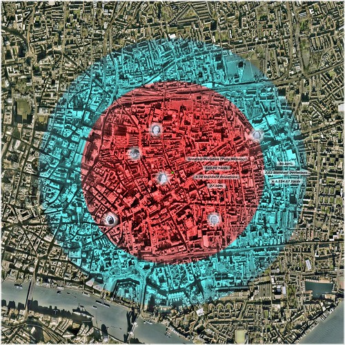
Murder 'Locale' - Immediate Vicinity; General Vicinity (Click to Enlarge in flickr)
Underlying Aerial Imagery: Copyright Google Earth, 2007
Overlying Plots, Labels and Color-Shadings: Copyright Colin C. Roberts, 2009
Red: Greatest Deviation (Polly Nichols) 0.00 - 1.38 Standard Deviations
- Radius: 843.50 Yards
- Area: 0.72 Square-Miles
- Expectation of Distribution Accumulation: 77.30%*
* Given a perception of late November 1888 that this series of murders would continue ad infinitum; the expectation should have been that 77.30% would occur within the specified circular area, i.e. within 1.38 Standard Deviations of the murder-site Mean-Center (green dot).
This can be loosely interpreted to mean that in late November 1888, the perceived probability of the impending subsequent murder occurring within this circular area, should have been 77.30%.
Red / Aqua: 0.00% - 90.00% Stipulated Expectation of Distribution Accumulation*
- 0.00 - 2.02 Standard Deviations
- Radius: 1,234.67 Yards
- Area: 1.55 Square-Miles
* Given a perception of late November 1888 that this series of murders would continue ad infinitum; the expectation should have been that 90.00% would occur within the specified circular area, i.e. within 2.02 Standard Deviations of the murder-site Mean-Center (green dot).
This can be loosely interpreted to mean that in late November 1888, the perceived probability of the impending subsequent murder occurring within this circular area, should have been 90.00%.
The 'Broad Vicinity' (Purple) will be explained, as my "Informal Presentation of Geo-Spatial Analysis Project" progresses.
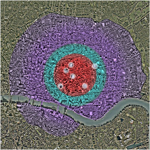
Murder 'Locale' - Immediate Vicinity; General Vicinity; Broad Vicinity (Click to Enlarge in flickr)
Underlying Aerial Imagery: Copyright Google Earth, 2007
Overlying Plots, Labels and Color-Shadings: Copyright Colin C. Roberts, 2009
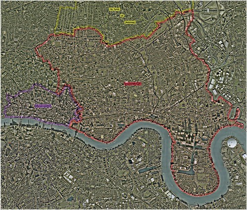
London's 'East End' - 1888 (Red) (Click to Enlarge in flickr)
Underlying Aerial Imagery: Copyright Google Earth, 2007
Overlying Plots, Labels and Color-Shadings: Copyright Colin C. Roberts, 2009
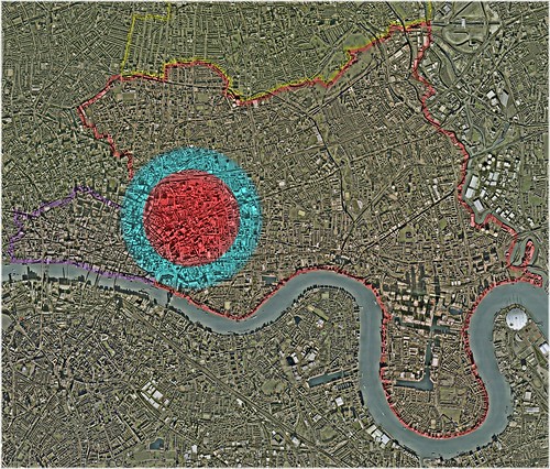
Murder 'Locale' in the Context of a Larger 'East End' (Red) (Click to Enlarge in flickr)
Underlying Aerial Imagery: Copyright Google Earth, 2007
Overlying Plots, Labels and Color-Shadings: Copyright Colin C. Roberts, 2009
Murder 'Locale' in the Context of a Larger 'East End' (Red) (Click to Enlarge in flickr)
Underlying Aerial Imagery: Copyright Google Earth, 2007
Overlying Plots, Labels and Color-Shadings: Copyright Colin C. Roberts, 2009
I have yet to compile a map, which depicts the three constituent Parliamentary sub-sets of London's 'East End' (1888); i.e. the Parliamentary Boroughs of Shoreditch, Bethnal Green, and Tower Hamlets. So, I should point out the following:
The Murder 'Locale' consumed nearly all of the Parliamentary Boroughs of Shoreditch (north-west) and Bethnal Green (north-center); but perhaps less than half of the Parliamentary Borough of Tower Hamlets.
That portion of the Parliamentary Borough of Tower Hamlets, which lay east of Regent's Canal …
… including portions of …
- The Parish of St. Matthew Bethnal Green
- The Hamlet of Mile End Old Town
- The Parish of St. Anne Limehouse
… and the entireties of …
- The Parish of St. Mary Stratford Bow
- The Parish of Bromley St. Leonard
- The Parish of All Saints Poplar
… was plainly and simply not 'local' to the series of so-called 'Whitechapel Murders', that occurred between 7 August 1888, and 9 November 1888.
---------
Once again; the 'Bottom Line':
I have estimated that the Parliamentary Borough of Tower Hamlets was inhabited by 141,852 females, between the ages of 12 and 59, in 1891; with as many as 19,462 (i.e. 13.72%) having been prostitutes:
- 1,360 exhibiting characteristics of Charles Booth's Class 'A'
- 5,398 exhibiting characteristics of Charles Booth's Class 'B'
- 5,454 exhibiting characteristics of Charles Booth's Class 'C' & 'D'
- 6,927 exhibiting characteristics of Charles Booth's Class 'E' & 'F'
- 324 exhibiting characteristics of Charles Booth's Class 'G' & 'H'
…
I have also estimated that London's 'East End' was inhabited by 223,490 females, between the ages of 12 and 59, in 1891; with as many as 31,187 (i.e. 13.95%) having been prostitutes:
- 1,967 exhibiting characteristics of Charles Booth's Class 'A'
- 8,850 exhibiting characteristics of Charles Booth's Class 'B'
- 9,319 exhibiting characteristics of Charles Booth's Class 'C' & 'D'
- 10,598 exhibiting characteristics of Charles Booth's Class 'E' & 'F'
- 454 exhibiting characteristics of Charles Booth's Class 'G' & 'H'
I have often felt that the term 'East End Prostitute' was perhaps somewhat misleading. Was there really such a 'genus' - so to speak - in London's eastern quarter, during the Victorian era? Or was the 'East End' much too large, much too heavily populated, and much too diverse to accommodate a widely distributed species of such presumable homogeneity?
I am quite convinced that prostitutes of London's 'East End' came in all shapes and sizes, and offered a wide variety of 'services', in the latter part of the nineteenth century; and that the manners, in which they conducted themselves, involved very few 'common denominators' that we today could describe as having been 'typical'.
The following exercise is an attempt to estimate the number of prostitutes that resided in London's 'East End', during the so-called 'Autumn of Terror'; by way of a perceived manner of distribution, across the spectrum of Charles Booth's socio-economic classifications.
...
Originally posted by Septic Blue
View Post
"In Poverty":
Class 'A': "Vicious" (i.e. vice-ridden); "Semi-Criminal"
Class 'B': "Very Poor"
Class 'C': "Poor" - Irregular Income
Class 'D': "Poor" - Regular but Inadequate Income
"In Comfort":
Class 'E': "Above the 'Line of Poverty'" - Regular "Standard" Income
Class 'F': "Highly Skilled Labour"
Class 'G': "Lower Middle-Class"
Class 'H': "Upper Middle-Class"
A graphic depiction …
Estimated Number of Prostitutes, In Proportion to the Estimated Number of Females (Ages 12-to-59), Within Each of Charles Booth's Delineations of Socio-Economic Class – The Parliamentary Borough of Tower Hamlets (1889-1891) (Click to Enlarge in flickr)
Backdrop: London's 'East End' – 1888
Underlying Aerial Imagery: Copyright Google Earth, 2007
Overlying Plots, Labels and Color-Shadings: Copyright Colin C. Roberts, 2009
… of the following estimations:
The Parliamentary Borough of Tower Hamlets:
Total Population - Female; Ages 12-to-59 (1891 Census): ~141,852
- Class 'A': 1,360 Prostitutes; From Amongst 2,039 Females (Ages 12-to-59)
- Class 'B': 5,398 Prostitutes; From Amongst 16,194 Females (Ages 12-to-59)
- Classes 'C' & 'D': 5,454 Prostitutes; From Amongst 32,723 Females (Ages 12-to-59)
Sub-Total (Below the 'Line of Poverty'): 12,211 Prostitutes; From Amongst 50,956 Females (Ages 12-to-59)
- Classes 'E' & 'F': 6,927 Prostitutes; From Amongst 83,120 Females (Ages 12-to-59)
- Classes 'G' & 'H': 324 Prostitutes; From Amongst 7,776 Females (Ages 12-to-59)
Sub-Total (Above the 'Line of Poverty'): 7,251 Prostitutes; From Amongst 90,896 Females (Ages 12-to-59)
Total: 19,462 Prostitutes; From Amongst 141,852 Females (Ages 12-to-59)
Put Simply:
I have estimated that the Parliamentary Borough of Tower Hamlets was inhabited by 141,852 females, between the ages of 12 and 59, in 1891; and that …
- 2,039 exhibited characteristics of Charles Booth's Class 'A'; with as many as 1,360 being prostitutes
- 16,194 exhibited characteristics of Charles Booth's Class 'B'; with as many as 5,398 being prostitutes
- 32,723 exhibited characteristics of Charles Booth's Classes 'C' & 'D'; with as many as 5,454 being prostitutes
- 83,120 exhibited characteristics of Charles Booth's Classes 'E' & 'F'; with as many as 6,927 being prostitutes
- 7,776 exhibited characteristics of Charles Booth's Classes 'G' & 'H'; with as many as 324 being prostitutes
... Or, More Simply:
I have estimated that the Parliamentary Borough of Tower Hamlets was inhabited by 141,852 females, between the ages of 12 and 59, in 1891; with as many as 19,462 (i.e. 13.72%) having been prostitutes:
- 1,360 exhibiting characteristics of Charles Booth's Class 'A'
- 5,398 exhibiting characteristics of Charles Booth's Class 'B'
- 5,454 exhibiting characteristics of Charles Booth's Class 'C' & 'D'
- 6,927 exhibiting characteristics of Charles Booth's Class 'E' & 'F'
- 324 exhibiting characteristics of Charles Booth's Class 'G' & 'H'
A graphic depiction …
Estimated Number of Prostitutes, In Proportion to the Estimated Number of Females (Ages 12-to-59), Within Each of Charles Booth's Delineations of Socio-Economic Class – London's 'East End' (1889-1891) (Click to Enlarge in flickr)
Backdrop: London's 'East End' – 1888
Underlying Aerial Imagery: Copyright Google Earth, 2007
Overlying Plots, Labels and Color-Shadings: Copyright Colin C. Roberts, 2009
… of the following estimations:
London's 'East End':
The Parliamentary Boroughs of Shoreditch, Bethnal Green, and Tower Hamlets
Total Population - Female; Ages 12-to-59 (1891 Census): ~223,490
- Class 'A': 1,967 Prostitutes; From Amongst 2,950 Females (Ages 12-to-59)
- Class 'B': 8,850 Prostitutes; From Amongst 26,549 Females (Ages 12-to-59)
- Classes 'C' & 'D': 9,319 Prostitutes; From Amongst 55,911 Females (Ages 12-to-59)
Sub-Total (Below the 'Line of Poverty'): 20,135 Prostitutes; From Amongst 85,410 Females (Ages 12-to-59)
- Classes 'E' & 'F': 10,598 Prostitutes; From Amongst 127,179 Females (Ages 12-to-59)
- Classes 'G' & 'H': 454 Prostitutes; From Amongst 10,901 Females (Ages 12-to-59)
Sub-Total (Above the 'Line of Poverty'): 11,052 Prostitutes; From Amongst 138,080 Females (Ages 12-to-59)
Total: 31,187 Prostitutes; From Amongst 223,490 Females (Ages 12-to-59)
Put Simply:
I have estimated that London's 'East End' was inhabited by 223,490 females, between the ages of 12 and 59, in 1891; and that …
- 2,950 exhibited characteristics of Charles Booth's Class 'A'; with as many as 1,967 being prostitutes
- 26,549 exhibited characteristics of Charles Booth's Class 'B'; with as many as 8,850 being prostitutes
- 55,911 exhibited characteristics of Charles Booth's Classes 'C' & 'D'; with as many as 9,319 being prostitutes
- 127,179 exhibited characteristics of Charles Booth's Classes 'E' & 'F'; with as many as 10,598 being prostitutes
- 10,901 exhibited characteristics of Charles Booth's Classes 'G' & 'H'; with as many as 454 being prostitutes
... Or, More Simply:
I have estimated that London's 'East End' was inhabited by 223,490 females, between the ages of 12 and 59, in 1891; with as many as 31,187 (i.e. 13.95%) having been prostitutes:
- 1,967 exhibiting characteristics of Charles Booth's Class 'A'
- 8,850 exhibiting characteristics of Charles Booth's Class 'B'
- 9,319 exhibiting characteristics of Charles Booth's Class 'C' & 'D'
- 10,598 exhibiting characteristics of Charles Booth's Class 'E' & 'F'
- 454 exhibiting characteristics of Charles Booth's Class 'G' & 'H'
...
That was, more-or-less, the 'Bottom Line'. The process, by which these estimations were derived, is as follows …
The 'Pool': Females; Ages 12-to-59
The Parliamentary Borough of Tower Hamlets
Whitechapel Registration District / Poor Law Union:
- The Liberty of Norton Folgate
- The Old Artillery Ground
- The Parish of Christ Church Spitalfields
- The Hamlet of Mile End New Town
- The Parish of Holy Trinity ('Minories')
- The Parish of St. Mary Whitechapel (portion within the County of Middlesex, -1889; the County of London, 1889-1965)
- The Liberty of Her Majesty's Tower of London
--- {The Liberty of the Tower}
--- {The Precinct of Old Tower Without}
--- {The Tower}
- The Precinct of St. Katharine
- The Parish of St. Botolph without Aldgate (portion within the County of Middlesex, -1889; the County of London, 1889-1965)
- Total Population (1891 Census): 74,462
- Total Population (Charles Booth 1889 Estimate): 73,518
- Percentage of Total Population Living Below the 'Line of Poverty' (Charles Booth 1889 Estimate): 39.20%
- Percentage of Total Population Living Above the 'Line of Poverty' (Charles Booth 1889 Estimate): 60.80%
- Total Population - Male (1891 Census): 38,935
- Total Population - Female (1891 Census): 35,527
- Total Population - Female; Ages 10-to-14 (1891 Census): 3,538
- Total Population - Female; Ages 15-to-19 (1891 Census): 3,709
- Total Population - Female; Ages 20-to-24 (1891 Census): 3,920
- Total Population - Female; Ages 25-to-29 (1891 Census): 3,219
- Total Population - Female; Ages 30-to-34 (1891 Census): 2,550
- Total Population - Female; Ages 35-to-39 (1891 Census): 2,044
- Total Population - Female; Ages 40-to-44 (1891 Census): 1,838
- Total Population - Female; Ages 45-to-49 (1891 Census): 1,473
- Total Population - Female; Ages 50-to-54 (1891 Census): 1,289
- Total Population - Female; Ages 55-to-59 (1891 Census): 894
- Total Population - Female; Ages 10-to-59 (1891 Census): 24,474
- Total Population - Female; Ages 12-to-59 (1891 Census): ~23,059*
* Figure for 'Ages 10-to-14' reduced by 40 percent.
Mile End Old Town Registration District / Poor Law Parish:
- The Hamlet of Mile End Old Town
- Total Population (1891 Census): 107,592
- Total Population (Charles Booth 1889 Estimate): 110,321
- Percentage of Total Population Living Below the 'Line of Poverty' (Charles Booth 1889 Estimate): 26.20%
- Percentage of Total Population Living Above the 'Line of Poverty' (Charles Booth 1889 Estimate): 73.80%
- Total Population - Male (1891 Census): 52,340
- Total Population - Female (1891 Census): 55,252
- Total Population - Female; Ages 10-to-14 (1891 Census): 5,729
- Total Population - Female; Ages 15-to-19 (1891 Census): 5,326
- Total Population - Female; Ages 20-to-24 (1891 Census): 5,431
- Total Population - Female; Ages 25-to-29 (1891 Census): 4,734
- Total Population - Female; Ages 30-to-34 (1891 Census): 3,850
- Total Population - Female; Ages 35-to-39 (1891 Census): 3,257
- Total Population - Female; Ages 40-to-44 (1891 Census): 2,962
- Total Population - Female; Ages 45-to-49 (1891 Census): 2,530
- Total Population - Female; Ages 50-to-54 (1891 Census): 2,141
- Total Population - Female; Ages 55-to-59 (1891 Census): 1,585
- Total Population - Female; Ages 10-to-59 (1891 Census): 37,545
- Total Population - Female; Ages 12-to-59 (1891 Census): ~35,253*
* Figure for 'Ages 10-to-14' reduced by 40 percent.
St. George in the East Registration District / Poor Law Parish:
- The Parish of St. George in the East
- Total Population (1891 Census): 45,795
- Total Population (Charles Booth 1889 Estimate): 47,578
- Percentage of Total Population Living Below the 'Line of Poverty' (Charles Booth 1889 Estimate): 48.80%
- Percentage of Total Population Living Above the 'Line of Poverty' (Charles Booth 1889 Estimate): 51.20%
- Total Population - Male (1891 Census): 23,096
- Total Population - Female (1891 Census): 22,699
- Total Population - Female; Ages 10-to-14 (1891 Census): 2,277
- Total Population - Female; Ages 15-to-19 (1891 Census): 2,112
- Total Population - Female; Ages 20-to-24 (1891 Census): 2,194
- Total Population - Female; Ages 25-to-29 (1891 Census): 1,983
- Total Population - Female; Ages 30-to-34 (1891 Census): 1,624
- Total Population - Female; Ages 35-to-39 (1891 Census): 1,311
- Total Population - Female; Ages 40-to-44 (1891 Census): 1,204
- Total Population - Female; Ages 45-to-49 (1891 Census): 974
- Total Population - Female; Ages 50-to-54 (1891 Census): 942
- Total Population - Female; Ages 55-to-59 (1891 Census): 605
- Total Population - Female; Ages 10-to-59 (1891 Census): 15,226
- Total Population - Female; Ages 12-to-59 (1891 Census): ~14,315*
* Figure for 'Ages 10-to-14' reduced by 40 percent.
Stepney Registration District / Poor Law Union:
- The Parish of St. John of Wapping
- The Parish of St. Paul Shadwell
- The Hamlet of Ratcliff
- The Parish of St. Anne Limehouse
- Total Population (1891 Census): 57,376
- Total Population (Charles Booth 1889 Estimate): 62,063
- Percentage of Total Population Living Below the 'Line of Poverty' (Charles Booth 1889 Estimate): 38.10%
- Percentage of Total Population Living Above the 'Line of Poverty' (Charles Booth 1889 Estimate): 61.90%
- Total Population - Male (1891 Census): 29,403
- Total Population - Female (1891 Census): 27,973
- Total Population - Female; Ages 10-to-14 (1891 Census): 3,092
- Total Population - Female; Ages 15-to-19 (1891 Census): 2,751
- Total Population - Female; Ages 20-to-24 (1891 Census): 2,589
- Total Population - Female; Ages 25-to-29 (1891 Census): 2,246
- Total Population - Female; Ages 30-to-34 (1891 Census): 1,989
- Total Population - Female; Ages 35-to-39 (1891 Census): 1,708
- Total Population - Female; Ages 40-to-44 (1891 Census): 1,542
- Total Population - Female; Ages 45-to-49 (1891 Census): 1,294
- Total Population - Female; Ages 50-to-54 (1891 Census): 1,100
- Total Population - Female; Ages 55-to-59 (1891 Census): 801
- Total Population - Female; Ages 10-to-59 (1891 Census): 19,112
- Total Population - Female; Ages 12-to-59 (1891 Census): ~17,875*
* Figure for 'Ages 10-to-14' reduced by 40 percent.
Poplar Registration District / Poor Law Union:
- The Parish of St. Mary Stratford Bow
- The Parish of Bromley St. Leonard
- The Parish of All Saints Poplar
- Total Population (1891 Census): 166,748
- Total Population (Charles Booth 1889 Estimate): 166,393
- Percentage of Total Population Living Below the 'Line of Poverty' (Charles Booth 1889 Estimate): 36.50%
- Percentage of Total Population Living Above the 'Line of Poverty' (Charles Booth 1889 Estimate): 63.50%
- Total Population - Male (1891 Census): 84,302
- Total Population - Female (1891 Census): 82,446
- Total Population - Female; Ages 10-to-14 (1891 Census): 9,192
- Total Population - Female; Ages 15-to-19 (1891 Census): 7,674
- Total Population - Female; Ages 20-to-24 (1891 Census): 6,997
- Total Population - Female; Ages 25-to-29 (1891 Census): 6,640
- Total Population - Female; Ages 30-to-34 (1891 Census): 5,755
- Total Population - Female; Ages 35-to-39 (1891 Census): 5,040
- Total Population - Female; Ages 40-to-44 (1891 Census): 4,464
- Total Population - Female; Ages 45-to-49 (1891 Census): 3,774
- Total Population - Female; Ages 50-to-54 (1891 Census): 3,222
- Total Population - Female; Ages 55-to-59 (1891 Census): 2,268
- Total Population - Female; Ages 10-to-59 (1891 Census): 55,026
- Total Population - Female; Ages 12-to-59 (1891 Census): ~51,349*
* Figure for 'Ages 10-to-14' reduced by 40 percent.
Total - The Parliamentary Borough of Tower Hamlets:
- Total Population (1891 Census): 451,973
- Total Population (Charles Booth 1889 Estimate): 459,873
- Percentage of Total Population Living Below the 'Line of Poverty' (Charles Booth 1889 Estimate): 35.95%
- Percentage of Total Population Living Above the 'Line of Poverty' (Charles Booth 1889 Estimate): 64.05%
- Total Population - Male (1891 Census): 228,076
- Total Population - Female (1891 Census): 223,897
- Total Population - Female; Ages 10-to-14 (1891 Census): 23,828
- Total Population - Female; Ages 15-to-19 (1891 Census): 21,572
- Total Population - Female; Ages 20-to-24 (1891 Census): 21,131
- Total Population - Female; Ages 25-to-29 (1891 Census): 18,822
- Total Population - Female; Ages 30-to-34 (1891 Census): 15,768
- Total Population - Female; Ages 35-to-39 (1891 Census): 13,360
- Total Population - Female; Ages 40-to-44 (1891 Census): 12,010
- Total Population - Female; Ages 45-to-49 (1891 Census): 10,045
- Total Population - Female; Ages 50-to-54 (1891 Census): 8,694
- Total Population - Female; Ages 55-to-59 (1891 Census): 6,153
- Total Population - Female; Ages 10-to-59 (1891 Census): 151,383
- Total Population - Female; Ages 12-to-59 (1891 Census): ~141,852*
* Figure for 'Ages 10-to-14' reduced by 40 percent.
London's 'East End':
The Parliamentary Boroughs of Shoreditch, Bethnal Green, and Tower Hamlets
The Parliamentary Borough of Shoreditch
Shoreditch Registration District / Poor Law Parish:
- The Parish of St. Leonard Shoreditch
- Total Population (1891 Census): 124,009
- Total Population (Charles Booth 1889 Estimate): 121,161
- Percentage of Total Population Living Below the 'Line of Poverty' (Charles Booth 1889 Estimate): 40.20%
- Percentage of Total Population Living Above the 'Line of Poverty' (Charles Booth 1889 Estimate): 59.80%
- Total Population - Male (1891 Census): 60,790
- Total Population - Female (1891 Census): 63,219
- Total Population - Female; Ages 10-to-14 (1891 Census): 6,652
- Total Population - Female; Ages 15-to-19 (1891 Census): 6,002
- Total Population - Female; Ages 20-to-24 (1891 Census): 5,993
- Total Population - Female; Ages 25-to-29 (1891 Census): 5,293
- Total Population - Female; Ages 30-to-34 (1891 Census): 4,555
- Total Population - Female; Ages 35-to-39 (1891 Census): 4,183
- Total Population - Female; Ages 40-to-44 (1891 Census): 3,392
- Total Population - Female; Ages 45-to-49 (1891 Census): 2,823
- Total Population - Female; Ages 50-to-54 (1891 Census): 2,472
- Total Population - Female; Ages 55-to-59 (1891 Census): 1,803
- Total Population - Female; Ages 10-to-59 (1891 Census): 43,168
- Total Population - Female; Ages 12-to-59 (1891 Census): ~40,507*
* Figure for 'Ages 10-to-14' reduced by 40 percent.
The Parliamentary Borough of Bethnal Green
Bethnal Green Registration District / Poor Law Parish:
- The Parish of St. Matthew Bethnal Green
- Total Population (1891 Census): 129,132
- Total Population (Charles Booth 1889 Estimate): 127,641
- Percentage of Total Population Living Below the 'Line of Poverty' (Charles Booth 1889 Estimate): 44.70%
- Percentage of Total Population Living Above the 'Line of Poverty' (Charles Booth 1889 Estimate): 55.30%
- Total Population - Male (1891 Census): 63,308
- Total Population - Female (1891 Census): 65,824
- Total Population - Female; Ages 10-to-14 (1891 Census): 7,251
- Total Population - Female; Ages 15-to-19 (1891 Census): 6,743
- Total Population - Female; Ages 20-to-24 (1891 Census): 6,111
- Total Population - Female; Ages 25-to-29 (1891 Census): 5,147
- Total Population - Female; Ages 30-to-34 (1891 Census): 4,399
- Total Population - Female; Ages 35-to-39 (1891 Census): 3,986
- Total Population - Female; Ages 40-to-44 (1891 Census): 3,481
- Total Population - Female; Ages 45-to-49 (1891 Census): 2,784
- Total Population - Female; Ages 50-to-54 (1891 Census): 2,454
- Total Population - Female; Ages 55-to-59 (1891 Census): 1,675
- Total Population - Female; Ages 10-to-59 (1891 Census): 44,031
- Total Population - Female; Ages 12-to-59 (1891 Census): ~41,131*
* Figure for 'Ages 10-to-14' reduced by 40 percent.
Total - London's 'East End':
The Parliamentary Boroughs of Shoreditch, Bethnal Green, and Tower Hamlets
- Total Population (1891 Census): 705,114
- Total Population (Charles Booth 1889 Estimate): 708,675
- Percentage of Total Population Living Below the 'Line of Poverty' (Charles Booth 1889 Estimate): 38.00%
- Percentage of Total Population Living Above the 'Line of Poverty' (Charles Booth 1889 Estimate): 62.00%
- Total Population - Male (1891 Census): 352,174
- Total Population - Female (1891 Census): 352,940
- Total Population - Female; Ages 10-to-14 (1891 Census): 37,731
- Total Population - Female; Ages 15-to-19 (1891 Census): 34,317
- Total Population - Female; Ages 20-to-24 (1891 Census): 33,235
- Total Population - Female; Ages 25-to-29 (1891 Census): 29,262
- Total Population - Female; Ages 30-to-34 (1891 Census): 24,722
- Total Population - Female; Ages 35-to-39 (1891 Census): 21,529
- Total Population - Female; Ages 40-to-44 (1891 Census): 18,883
- Total Population - Female; Ages 45-to-49 (1891 Census): 15,652
- Total Population - Female; Ages 50-to-54 (1891 Census): 13,620
- Total Population - Female; Ages 55-to-59 (1891 Census): 9,631
- Total Population - Female; Ages 10-to-59 (1891 Census): 238,582
- Total Population - Female; Ages 12-to-59 (1891 Census): ~223,490*
* Figure for 'Ages 10-to-14' reduced by 40 percent.
...
Distribution of Total Population, Across the Spectrum of Charles Booth's Socio-Economic Classifications:
The Parliamentary Borough of Tower Hamlets
Whitechapel Registration District / Poor Law Union:
- The Liberty of Norton Folgate
- The Old Artillery Ground
- The Parish of Christ Church Spitalfields
- The Hamlet of Mile End New Town
- The Parish of Holy Trinity ('Minories')
- The Parish of St. Mary Whitechapel (portion within the County of Middlesex, -1889; the County of London, 1889-1965)
- The Liberty of Her Majesty's Tower of London
--- {The Liberty of the Tower}
--- {The Precinct of Old Tower Without}
--- {The Tower}
- The Precinct of St. Katharine
- The Parish of St. Botolph without Aldgate (portion within the County of Middlesex, -1889; the County of London, 1889-1965)
- Total Population (Charles Booth 1889 Estimate): 73,518
Class 'A': 2,426 (3.30%)
Class 'B': 6,543 (8.90%)
Classes 'C' & 'D': 19,850 (27.00%)
Sub-Total (Below the 'Line of Poverty'): 28,819 (39.20%)
Classes 'E' & 'F': 40,729 (55.40%)
Classes 'G' & 'H': 3,970 (5.40%)
Sub-Total (Above the 'Line of Poverty'): 44,699 (60.80%)
Mile End Old Town Registration District / Poor Law Parish:
- The Hamlet of Mile End Old Town
- Total Population (Charles Booth 1889 Estimate): 110,321
Class 'A': 772 (0.70%)
Class 'B': 7,502 (6.80%)
Classes 'C' & 'D': 20,520 (18.60%)
Sub-Total (Below the 'Line of Poverty'): 28,794 (26.10%)
Classes 'E' & 'F': 73,805 (66.90%)
Classes 'G' & 'H': 7,722 (7.00%)
Sub-Total (Above the 'Line of Poverty'): 81,527 (73.90%)
St. George in the East Registration District / Poor Law Parish:
- The Parish of St. George in the East
- Total Population (Charles Booth 1889 Estimate): 47,578
Class 'A': 714 (1.50%)
Class 'B': 7,184 (15.10%)
Classes 'C' & 'D': 15,368 (32.30%)
Sub-Total (Below the 'Line of Poverty'): 23,266 (48.90%)
Classes 'E' & 'F': 23,170 (48.70%)
Classes 'G' & 'H': 1,142 (2.40%)
Sub-Total (Above the 'Line of Poverty'): 24,312 (51.10%)
Stepney Registration District / Poor Law Union:
- The Parish of St. John of Wapping
- The Parish of St. Paul Shadwell
- The Hamlet of Ratcliff
- The Parish of St. Anne Limehouse
- Total Population (Charles Booth 1889 Estimate): 62,063
Class 'A': 869 (1.40%)
Class 'B': 9,806 (15.80%)
Classes 'C' & 'D': 12,909 (20.80%)
Sub-Total (Below the 'Line of Poverty'): 23,584 (38.00%)
Classes 'E' & 'F': 34,259 (55.20%)
Classes 'G' & 'H': 4,220 (6.80%)
Sub-Total (Above the 'Line of Poverty'): 38,479 (62.00%)
Poplar Registration District / Poor Law Union:
- The Parish of St. Mary Stratford Bow
- The Parish of Bromley St. Leonard
- The Parish of All Saints Poplar
- Total Population (Charles Booth 1889 Estimate): 166,393
Class 'A': 1,830 (1.10%)
Class 'B': 21,465 (12.90%)
Classes 'C' & 'D': 37,438 (22.50%)
Sub-Total (Below the 'Line of Poverty'): 60,733 (36.50%)
Classes 'E' & 'F': 97,506 (58.60%)
Classes 'G' & 'H': 8,153 (4.90%)
Sub-Total (Above the 'Line of Poverty'): 105,660 (63.50%)
Total - Parliamentary Borough of Tower Hamlets:
- Total Population (Charles Booth 1889 Estimate): 459,873
Class 'A': 6,611 (1.44%)
Class 'B': 52,500 (11.42%)
Classes 'C' & 'D': 106,085 (23.07%)
Sub-Total (Below the 'Line of Poverty'): 165,196 (35.92%)
Classes 'E' & 'F': 269,469 (58.60%)
Classes 'G' & 'H': 25,208 (5.48%)
Sub-Total (Above the 'Line of Poverty'): 294,677 (64.08%)
London's 'East End':
The Parliamentary Boroughs of Shoreditch, Bethnal Green, and Tower Hamlets
The Parliamentary Borough of Shoreditch
Shoreditch Registration District / Poor Law Parish:
- The Parish of St. Leonard Shoreditch
- Total Population (Charles Booth 1889 Estimate): 121,161
Class 'A': 1,212 (1.00%)
Class 'B': 11,389 (9.40%)
Classes 'C' & 'D': 36,106 (29.80%)
Sub-Total (Below the 'Line of Poverty'): 48,707 (40.20%)
Classes 'E' & 'F': 68,456 (56.50%)
Classes 'G' & 'H': 3,998 (3.30%)
Sub-Total (Above the 'Line of Poverty'): 72,454 (59.80%)
The Parliamentary Borough of Bethnal Green
Bethnal Green Registration District / Poor Law Parish:
- The Parish of St. Matthew Bethnal Green
- Total Population (Charles Booth 1889 Estimate): 127,641
Class 'A': 1,532 (1.20%)
Class 'B': 20,295 (15.90%)
Classes 'C' & 'D': 35,101 (27.50%)
Sub-Total (Below the 'Line of Poverty'): 56,928 (44.60%)
Classes 'E' & 'F': 65,352 (51.20%)
Classes 'G' & 'H': 5,361 (4.20%)
Sub-Total (Above the 'Line of Poverty'): 70,713 (55.40%)
Total - London's 'East End':
The Parliamentary Boroughs of Shoreditch, Bethnal Green, and Tower Hamlets
- Total Population (Charles Booth 1889 Estimate): 708,675
Class 'A': 9,355 (1.32%)
Class 'B': 84,184 (11.88%)
Classes 'C' & 'D': 177,292 (25.02%)
Sub-Total (Below the 'Line of Poverty'): 270,830 (38.22%)
Classes 'E' & 'F': 403,277 (56.91%)
Classes 'G' & 'H': 34,567 (4.88%)
Sub-Total (Above the 'Line of Poverty'): 437,845 (61.78%)
...
Distribution of the 'Pool' (Females; Ages 12-to-59), Across the Spectrum of Charles Booth's Socio-Economic Classifications:
The Parliamentary Borough of Tower Hamlets:
- Total Population - Female; Ages 12-to-59 (1891 Census): ~141,852
Class 'A': 2,039 (1.44%)
Class 'B': 16,194 (11.42%)
Classes 'C' & 'D': 32,723 (23.07%)
Sub-Total (Below the 'Line of Poverty'): 50,956 (35.92%)
Classes 'E' & 'F': 83,120 (58.60%)
Classes 'G' & 'H': 7,776 (5.48%)
Sub-Total (Above the 'Line of Poverty'): 90,896 (64.08%)
London's 'East End':
The Parliamentary Boroughs of Shoreditch, Bethnal Green, and Tower Hamlets
- Total Population - Female; Ages 12-to-59 (1891 Census): ~223,490
Class 'A': 2,950 (1.32%)
Class 'B': 26,549 (11.88%)
Classes 'C' & 'D': 55,911 (25.02%)
Sub-Total (Below the 'Line of Poverty'): 85,410 (38.22%)
Classes 'E' & 'F': 127,179 (56.91%)
Classes 'G' & 'H': 10,901 (4.88%)
Sub-Total (Above the 'Line of Poverty'): 138,080 (61.78%)
...
Distribution of the 'Pool' (Females; Ages 12-to-59), Across the Spectrum of Charles Booth's Socio-Economic Classifications; in Accordance with the Following 'Model' Adjustment*:
"In Poverty":
Class 'A'; "Vicious / Semi-Criminal": 2/3, i.e. 66.67%
Class 'B'; "Very Poor": 1/3, i.e. 33.33%
Classes 'C' & 'D'; "Poor": 1/6, i.e. 16.67%
"In Comfort":
Classes 'E' & 'F'; "Comfortable": 1/12, i.e. 8.33%
Classes 'G' & 'H'; "Middle-Class": 1/24, i.e. 4.17%
* The 'Model' assumes that two thirds (2/3) of all females exhibiting characteristics of Class 'A', were likely to have been prostitutes; … that one third (1/3) of all females exhibiting characteristics of Class 'B', were likely to have been prostitutes; … that one sixth (1/6) of all females exhibiting characteristics of Classes 'C' & 'D', were likely to have been prostitutes; … etc …
The Parliamentary Borough of Tower Hamlets:
- Total Population - Female; Ages 12-to-59 (1891 Census): ~141,852
Class 'A': 1,360 ( 0.96%)
Class 'B': 5,398 (3.81%)
Classes 'C' & 'D': 5,454 (3.84%)
Sub-Total (Below the 'Line of Poverty'): 12,211 (8.61%)
Classes 'E' & 'F': 6,927 (4.88%)
Classes 'G' & 'H': 324 (0.23%)
Sub-Total (Above the 'Line of Poverty'): 7,251 (5.11%)
Total: 19,462 (13.72%)
London's 'East End':
The Parliamentary Boroughs of Shoreditch, Bethnal Green, and Tower Hamlets
- Total Population - Female; Ages 12-to-59 (1891 Census): ~223,490
Class 'A': 1,967 (0.88%)
Class 'B': 8,850 (3.96%)
Classes 'C' & 'D': 9,319 (4.17%)
Sub-Total (Below the 'Line of Poverty'): 20,135 (9.01%)
Classes 'E' & 'F': 10,598 (4.74%)
Classes 'G' & 'H': 454 (0.20%)
Sub-Total (Above the 'Line of Poverty'): 11,052 (4.95%)
Total: 31,187 (13.95%)
...
Geographic Perspective
Murder 'Locale' - Immediate Vicinity; General Vicinity (Click to Enlarge in flickr)
Underlying Aerial Imagery: Copyright Google Earth, 2007
Overlying Plots, Labels and Color-Shadings: Copyright Colin C. Roberts, 2009
Red: Greatest Deviation (Polly Nichols) 0.00 - 1.38 Standard Deviations
- Radius: 843.50 Yards
- Area: 0.72 Square-Miles
- Expectation of Distribution Accumulation: 77.30%*
* Given a perception of late November 1888 that this series of murders would continue ad infinitum; the expectation should have been that 77.30% would occur within the specified circular area, i.e. within 1.38 Standard Deviations of the murder-site Mean-Center (green dot).
This can be loosely interpreted to mean that in late November 1888, the perceived probability of the impending subsequent murder occurring within this circular area, should have been 77.30%.
Red / Aqua: 0.00% - 90.00% Stipulated Expectation of Distribution Accumulation*
- 0.00 - 2.02 Standard Deviations
- Radius: 1,234.67 Yards
- Area: 1.55 Square-Miles
* Given a perception of late November 1888 that this series of murders would continue ad infinitum; the expectation should have been that 90.00% would occur within the specified circular area, i.e. within 2.02 Standard Deviations of the murder-site Mean-Center (green dot).
This can be loosely interpreted to mean that in late November 1888, the perceived probability of the impending subsequent murder occurring within this circular area, should have been 90.00%.
The 'Broad Vicinity' (Purple) will be explained, as my "Informal Presentation of Geo-Spatial Analysis Project" progresses.
Murder 'Locale' - Immediate Vicinity; General Vicinity; Broad Vicinity (Click to Enlarge in flickr)
Underlying Aerial Imagery: Copyright Google Earth, 2007
Overlying Plots, Labels and Color-Shadings: Copyright Colin C. Roberts, 2009
London's 'East End' - 1888 (Red) (Click to Enlarge in flickr)
Underlying Aerial Imagery: Copyright Google Earth, 2007
Overlying Plots, Labels and Color-Shadings: Copyright Colin C. Roberts, 2009
Murder 'Locale' in the Context of a Larger 'East End' (Red) (Click to Enlarge in flickr)
Underlying Aerial Imagery: Copyright Google Earth, 2007
Overlying Plots, Labels and Color-Shadings: Copyright Colin C. Roberts, 2009
Murder 'Locale' in the Context of a Larger 'East End' (Red) (Click to Enlarge in flickr)
Underlying Aerial Imagery: Copyright Google Earth, 2007
Overlying Plots, Labels and Color-Shadings: Copyright Colin C. Roberts, 2009
I have yet to compile a map, which depicts the three constituent Parliamentary sub-sets of London's 'East End' (1888); i.e. the Parliamentary Boroughs of Shoreditch, Bethnal Green, and Tower Hamlets. So, I should point out the following:
The Murder 'Locale' consumed nearly all of the Parliamentary Boroughs of Shoreditch (north-west) and Bethnal Green (north-center); but perhaps less than half of the Parliamentary Borough of Tower Hamlets.
That portion of the Parliamentary Borough of Tower Hamlets, which lay east of Regent's Canal …
… including portions of …
- The Parish of St. Matthew Bethnal Green
- The Hamlet of Mile End Old Town
- The Parish of St. Anne Limehouse
… and the entireties of …
- The Parish of St. Mary Stratford Bow
- The Parish of Bromley St. Leonard
- The Parish of All Saints Poplar
… was plainly and simply not 'local' to the series of so-called 'Whitechapel Murders', that occurred between 7 August 1888, and 9 November 1888.
---------
Once again; the 'Bottom Line':
I have estimated that the Parliamentary Borough of Tower Hamlets was inhabited by 141,852 females, between the ages of 12 and 59, in 1891; with as many as 19,462 (i.e. 13.72%) having been prostitutes:
- 1,360 exhibiting characteristics of Charles Booth's Class 'A'
- 5,398 exhibiting characteristics of Charles Booth's Class 'B'
- 5,454 exhibiting characteristics of Charles Booth's Class 'C' & 'D'
- 6,927 exhibiting characteristics of Charles Booth's Class 'E' & 'F'
- 324 exhibiting characteristics of Charles Booth's Class 'G' & 'H'
…
I have also estimated that London's 'East End' was inhabited by 223,490 females, between the ages of 12 and 59, in 1891; with as many as 31,187 (i.e. 13.95%) having been prostitutes:
- 1,967 exhibiting characteristics of Charles Booth's Class 'A'
- 8,850 exhibiting characteristics of Charles Booth's Class 'B'
- 9,319 exhibiting characteristics of Charles Booth's Class 'C' & 'D'
- 10,598 exhibiting characteristics of Charles Booth's Class 'E' & 'F'
- 454 exhibiting characteristics of Charles Booth's Class 'G' & 'H'


 Sink the Bismark
Comment