
 Tweet
Tweet
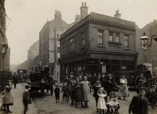
The uncropped 1912 image:
-
-
JtRmap.com<< JtR Interactive Map
JtRmap FORM << Use this form to make suggestions for map annotations
---------------------------------------------------
JtR3d.com << JtR 3D & #VR Website
---------------------------------------------------Comment
-
So, this is the corner of Dorset St and Crispin Street? For sure?
Are we talking this corner?Originally posted by MrBarnett View Post
 JtRmap.com<< JtR Interactive Map
JtRmap FORM << Use this form to make suggestions for map annotations
---------------------------------------------------
JtR3d.com << JtR 3D & #VR Website
---------------------------------------------------Comment
-
-
Question: In that Goad's map (above), what is the big blue circle (above the 45' mark)?
thanksJtRmap.com<< JtR Interactive Map
JtRmap FORM << Use this form to make suggestions for map annotations
---------------------------------------------------
JtR3d.com << JtR 3D & #VR Website
---------------------------------------------------Comment
-
-
Thanks,
assuming it was not removed, would/should a fire hydrant be visible in the photo?
Originally posted by MrBarnett View PostJtRmap.com<< JtR Interactive Map
JtRmap FORM << Use this form to make suggestions for map annotations
---------------------------------------------------
JtR3d.com << JtR 3D & #VR Website
---------------------------------------------------Comment
-
If it was where it appears on the map it would be under the cart.Comment
-
Probably an in ground hydrant not the big red things Americans think of.G U T
There are two ways to be fooled, one is to believe what isn't true, the other is to refuse to believe that which is true.
Comment
-
Yes, GUT, and probably set into the pavement.Originally posted by GUT View Post
Here's the corner in 1914:
Comment
-
I have a booklet of C. A. Mathew's photos which I obtained from the Bishopsgate institute in 1974. The image of the HoP is a bit clearer than what has been posted and clearly shows the pub had a tiled frontage. This was very much a turn of the century style, and to me the brick detailing on the upper storey also looks late 19th century. So either the pub was heavily refurbished ca 1890 or it was completely rebuilt.
In which case, this may not have been the building in which MJK is said to have drunk.Last edited by MrBarnett; 05-27-2017, 04:40 AM.Comment
-
Does anyone else think that the ground floor looks vaguely similar to the nearby Duke of Wellington pub?
Comment
-
Actually, the updated image is the original! Sorry.
This is the updated image showing the missing building:

Originally posted by richardh View PostJtRmap.com<< JtR Interactive Map
JtRmap FORM << Use this form to make suggestions for map annotations
---------------------------------------------------
JtR3d.com << JtR 3D & #VR Website
---------------------------------------------------Comment


Comment