Announcement

Collapse
No announcement yet.

Mr. Rippers Neighborhood

Collapse
X
 
  • Filter
  • Time
  • Show
Clear All
new posts

  • #16
    a note on pubs as placemarks

    It has been suggested and I would be remiss in not discussing it. Aside from the ambiguity of selecting which building corresponds to the ph on the map, there are other issues. Anyone familiar with my awkward steps towards understanding the terrain, knows that I could screw up just about anything. With numbering conventions varying by street, and some buildings containing more than one address ( not predictable by size on map), the potential for error grows too large. It is in this environment that the Mr. Ripper's Neighborhood project relies on maps posted by you fine users of casebook. Just recently Durward street, Brady Street, and Thrawl street had remarkable progress made. I ask again, if you have maps in an electronic form, or know the link to maps, please post them and I will load them in to Mr. Ripper's hood. Additionally, if someone familiar with google earth and the census returns for 1881 and 1891 wanted to volunteer, there is enough data to get started on adding the return data to the addresses. Dave
    We are all born cute as a button and dumb as rocks. We grow out of cute fast!

    Comment


    • #17
      mrn 6/11/10

      The plots are in as are the links. I will add the postal directory information tomorrow. Thank You all that haved and will help. Dave
      Attached Files
      We are all born cute as a button and dumb as rocks. We grow out of cute fast!

      Comment


      • #18
        Census returns 1891

        You can find some of the census data for 1891 here: http://www.census1891.com/

        It's free but not yet complete.

        Regards.

        Geoff

        Comment


        • #19
          a hitch in my giddyup

          I have a problem reconciling Simon's 1888 ord. sur. map with the link CooperGl posted. Specifically, they differ in the number of terrace cottages. Someone please advise. Dave
          We are all born cute as a button and dumb as rocks. We grow out of cute fast!

          Comment


          • #20
            Originally posted by protohistorian View Post
            I have a problem reconciling Simon's 1888 ord. sur. map with the link CooperGl posted. Specifically, they differ in the number of terrace cottages. Someone please advise. Dave
            Ignore the Bucks Row in the CooperGl link as it is completely inaccurate.

            Rob

            Comment


            • #21
              Originally posted by protohistorian View Post
              I have a problem reconciling Simon's 1888 ord. sur. map with the link CooperGl posted. Specifically, they differ in the number of terrace cottages. Someone please advise. Dave
              Hi Dave.

              There's no such thing as an 1888 ordnance survey map. I have an 1873 ordnance survey map and an 1894 ordnance survey map and my data interpolating the two comes from the 1881 and 1891 censusses.

              What particular street are you referring to?

              Regards.

              Geoff.

              Comment


              • #22
                Bucks Row Clarification

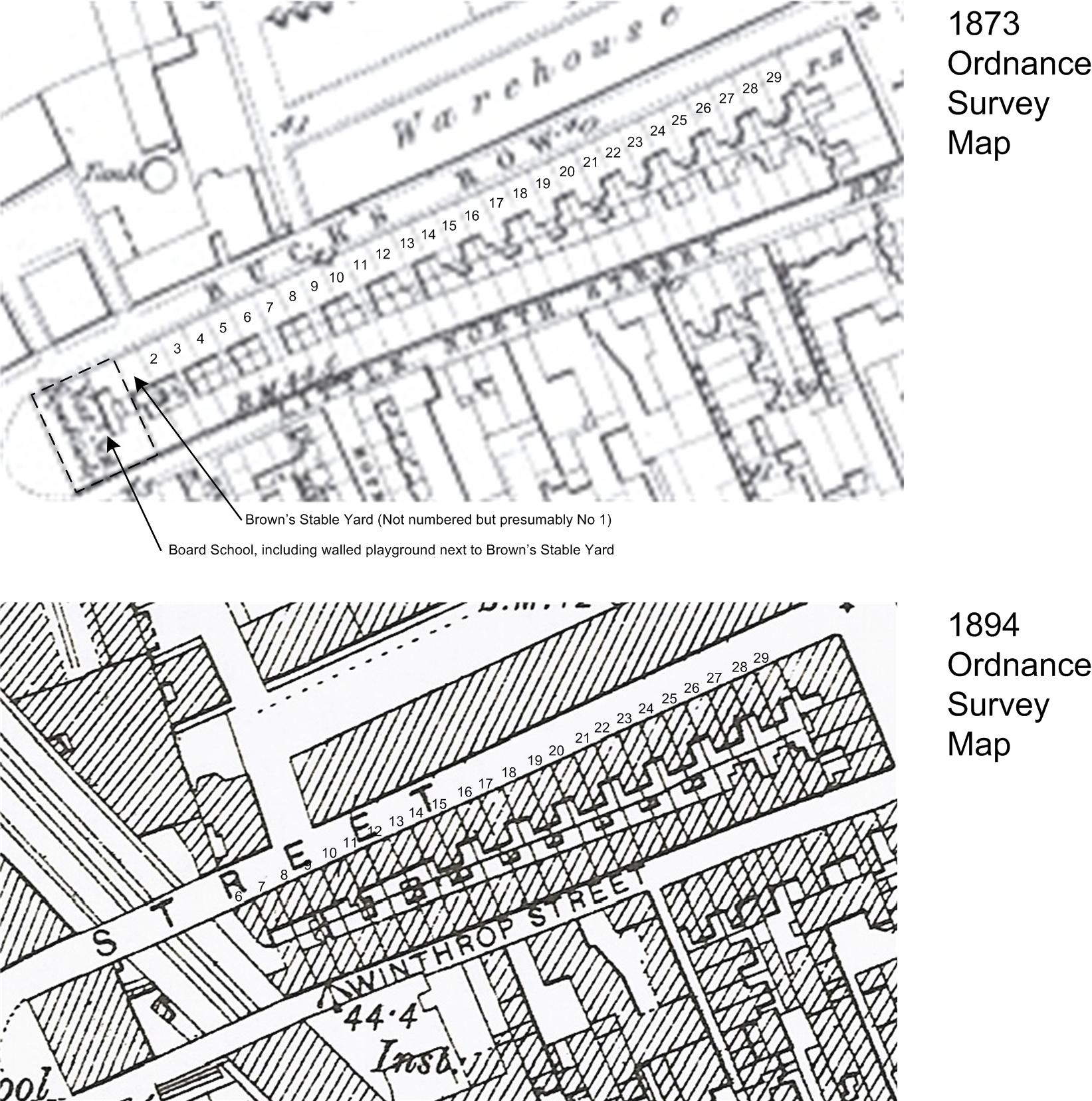
                We need some clarification on Bucks Row. I'm going to try and attach an image here which show Bucks row from both the 1873 and 1894 ordnance survey maps.


                We know from the press and police reports that No 2 Bucks Row (also known as New Cottage), was next door to Brown's stable yard, which was in turn next to the Board school. These can all be seen reasonably clearly on the 1873 ordnance survey map.

                We also know that several houses were demolished in 1889 to make way for Whitechapel station.

                The 1891 census shows the people living in Nos 6 to 29 http://www.census1891.com This is clearly shown on the 1894 ordnance survey map.

                I hope this clears up any confusion.

                Regards.

                Geoff.

                Comment


                • #23
                  thanks

                  Thank you CooperGL! Dave
                  We are all born cute as a button and dumb as rocks. We grow out of cute fast!

                  Comment


                  • #24
                    Some corrections to Geoff's post.

                    Numbers 1 to 4 Bucks Row on the 1873 map had been demolished by November 1874

                    Click image for larger version

Name:	Bucks Row 6 November 1874.jpg
Views:	1
Size:	45.6 KB
ID:	659615

                    The Board School in the 1873 map is not the same one that was there in 1888. That one was built around 1878 and still stands today as residential flats.

                    Essex Wharf was built between 1876 and 1881.
                    New Cottage was also built around this time as well. Numbers 5 and 6 of the old cottages were demolished and the site of number 5 became Browns Stable Yard and New Cottage was built on the site of number 6 and retaining that number.

                    The numbering gets quite confusing, and is difficult to sort out. Whites Row in the early 1880s only went from Bakers Row to Thomas Street, and the numbering was 1 to 25. Bucks Row began at Thomas Street and extended all the way to Brady Street. Numbers 1 to 5 was on the North side between Thomas Street and Court Street and numbers 6 to 29 was on the South side.

                    By 1888 Whites Row extended from Bakers Row all the way to the Board School and the numbering went from 1 to 35 and so that's why on the 1891 Census there was no 1 to 5 Bucks Row.

                    This is what Bucks Row would have looked like in 1888.


                    On the left in orange was 1 to 5 Bucks Row in the 1881 Census but by 1888 was now 27 to 35 Whites Row.
                    Red is Essex Wharf
                    Blue is number 6 New Cottage.
                    Green is Harrison Barber and Co. Horse Slaughterers.

                    The East London Line opened in 1876 and the District Line opened in 1884

                    Rob

                    Comment


                    • #25
                      Thank You Mr. Clack, that helps me jive to my 1894 survey map. I started at 29 and worked down but kept ending up at 6. Just so anyone who wants to help with MRN knows, The primary map strata used is an 1894 survey map. Once I have the areas that did not change done I can address the issue of changing geography. As to numberings, I need the 1888 numberings as I am using the 1888 postal directory. Dave
                      We are all born cute as a button and dumb as rocks. We grow out of cute fast!

                      Comment


                      • #26
                        Thanks for the update Rob

                        You're obviously in possession of a lot more information than me. I'll have to do some more research, maybe get some Goad maps.

                        If what you say is true, then where on your version of the 1888 map is Browns Stable Yard, because according to Police and Press reports, it was right next door to New Cottage?

                        Best Regards.

                        Geoff.

                        Comment


                        • #27
                          Hi Geoff,

                          I've marked it in blue.

                          Click image for larger version

Name:	Bucks Row 1888 Barbers Yard.jpg
Views:	1
Size:	74.6 KB
ID:	659616

                          Regards

                          Rob

                          Comment


                          • #28
                            Thanks for that clarification Rob. I'll update my maps accordingly.

                            Shame the Goad maps only cover Industrial/Commercial properties. We could have had this sorted much sooner.

                            Geoff

                            Comment


                            • #29
                              finally, I figured it out

                              Mr. Rippers hood can now begin in earnest. Project 1 is defining the areas around body recovery sites. I only have 1 street done so far in the Nichols area ( within 500 ft) of body. So in that light I present whitechapel road. The red lines define the area. Placemarks are as follows, $=a place where money is exchanged (banks,pawnshops), m=manufacturing of some sort, r=retail, s=services, and the image with multiple types is the stuff I cannot categorize with precision. Dave
                              Attached Files
                              We are all born cute as a button and dumb as rocks. We grow out of cute fast!

                              Comment


                              • #30
                                and f=food or beverage to include alcohol. Dave
                                We are all born cute as a button and dumb as rocks. We grow out of cute fast!

                                Comment

                                Working...
                                X